
Spenden
Rüste dich für dein nächstes Abenteuer:
Als Amazon-Partner verdient diese Seite an qualifizierten Käufen, ohne dass Ihnen zusätzliche Kosten entstehen.
Topografische Karte Fleetwood
Klicken Sie auf die Karte, um die Höhe anzuzeigen.
Spenden
Rüste dich für dein nächstes Abenteuer:
Als Amazon-Partner verdient diese Seite an qualifizierten Käufen, ohne dass Ihnen zusätzliche Kosten entstehen.
Über diese Karte
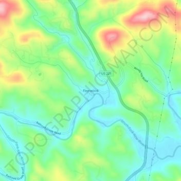
Name: Topografische Karte Fleetwood, Höhe, Relief.
Ort: Fleetwood, Ashe County, North Carolina, 28626, United States (36.28624 -81.53344 36.32624 -81.49344)
Durchschnittliche Höhe: 936 m
Minimale Höhe: 864 m
Maximale Höhe: 1’078 m
Spenden
Rüste dich für dein nächstes Abenteuer:
Als Amazon-Partner verdient diese Seite an qualifizierten Käufen, ohne dass Ihnen zusätzliche Kosten entstehen.
Andere topografische Karten
Klicken Sie auf eine Karte, um ihre Topografie, ihre Höhe und ihr Relief anzuzeigen.
West Jefferson
United States > North Carolina > Ashe County
West Jefferson is a popular destination among tourists and retirees from Florida, as well as those from the lower elevations of the Carolinas and Georgia.
Durchschnittliche Höhe: 1’002 m
Lansing
United States > North Carolina > Ashe County
Lansing is a popular destination among retirees and tourists from Florida, as well as those from the lower elevations of the Carolinas and Georgia.
Durchschnittliche Höhe: 879 m
Jefferson
United States > North Carolina > Ashe County
Due to its high elevation, Jefferson has an oceanic or subtropical highland climate, (Köppen Cfb), with the coldst month of January averaging slightly above freezing, while summers are much milder than most of the southeast, with July averaging below 70 degrees fahrenheit.
Durchschnittliche Höhe: 979 m
Spenden
Rüste dich für dein nächstes Abenteuer:
Als Amazon-Partner verdient diese Seite an qualifizierten Käufen, ohne dass Ihnen zusätzliche Kosten entstehen.
West Jefferson
United States > North Carolina > Ashe County
West Jefferson is a popular destination among tourists and retirees from Florida, as well as those from the lower elevations of the Carolinas and Georgia.
Durchschnittliche Höhe: 1’002 m