
Spenden
Rüste dich für dein nächstes Abenteuer:
Als Amazon-Partner verdient diese Seite an qualifizierten Käufen, ohne dass Ihnen zusätzliche Kosten entstehen.
Topografische Karte Seneca Castle
Klicken Sie auf die Karte, um die Höhe anzuzeigen.
Spenden
Rüste dich für dein nächstes Abenteuer:
Als Amazon-Partner verdient diese Seite an qualifizierten Käufen, ohne dass Ihnen zusätzliche Kosten entstehen.
Über diese Karte
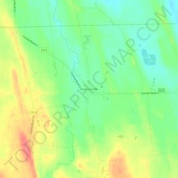
Name: Topografische Karte Seneca Castle, Höhe, Relief.
Durchschnittliche Höhe: 244 m
Minimale Höhe: 216 m
Maximale Höhe: 279 m
Spenden
Rüste dich für dein nächstes Abenteuer:
Als Amazon-Partner verdient diese Seite an qualifizierten Käufen, ohne dass Ihnen zusätzliche Kosten entstehen.
Andere topografische Karten
Klicken Sie auf eine Karte, um ihre Topografie, ihre Höhe und ihr Relief anzuzeigen.
Town of Farmington
United States > New York > Ontario County
The land, at an average elevation of 600 feet above sea level, is compressed by the Wisconsin glaciation and slopes from an elevation of 700 feet at the southern border with the town of Canandaigua, to 500 feet at the north boundary with the town of Macedon. The land comprises drumlins and eskers. Other than…
Durchschnittliche Höhe: 185 m
Spenden
Rüste dich für dein nächstes Abenteuer:
Als Amazon-Partner verdient diese Seite an qualifizierten Käufen, ohne dass Ihnen zusätzliche Kosten entstehen.
Honeoye
United States > New York > Ontario County > Town of Richmond
Honeoye is located at 42°47′24″N 077°31′01″W / 42.79000°N 77.51694°W / 42.79000; -77.51694 (42.7900646, -77.5169374) and its elevation is 814 feet (248 m).
Durchschnittliche Höhe: 268 m
Spenden
Rüste dich für dein nächstes Abenteuer:
Als Amazon-Partner verdient diese Seite an qualifizierten Käufen, ohne dass Ihnen zusätzliche Kosten entstehen.
Spenden
Rüste dich für dein nächstes Abenteuer:
Als Amazon-Partner verdient diese Seite an qualifizierten Käufen, ohne dass Ihnen zusätzliche Kosten entstehen.
Spenden
Rüste dich für dein nächstes Abenteuer:
Als Amazon-Partner verdient diese Seite an qualifizierten Käufen, ohne dass Ihnen zusätzliche Kosten entstehen.
Town of Farmington
United States > New York > Ontario County
The land, at an average elevation of 600 feet above sea level, is compressed by the Wisconsin glaciation and slopes from an elevation of 700 feet at the southern border with the town of Canandaigua, to 500 feet at the north boundary with the town of Macedon. The land comprises drumlins and eskers. Other than…
Durchschnittliche Höhe: 185 m
Spenden
Rüste dich für dein nächstes Abenteuer:
Als Amazon-Partner verdient diese Seite an qualifizierten Käufen, ohne dass Ihnen zusätzliche Kosten entstehen.