
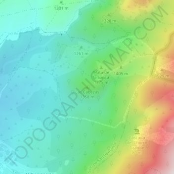
Topografische Karte Las Cabezas
Interaktive Karte
Klicken Sie auf die Karte, um die Höhe anzuzeigen.
Über diese Karte
Name: Topografische Karte Las Cabezas, Höhe, Relief.
Durchschnittliche Höhe: 1’316 m
Minimale Höhe: 1’135 m
Maximale Höhe: 1’751 m
Andere topografische Karten
Klicken Sie auf eine Karte, um ihre Topografie, ihre Höhe und ihr Relief anzuzeigen.
Puerto de Cotos
España > Castilla y León > Real Sitio de San Ildefonso
Puerto de Cotos, Real Sitio de San Ildefonso, Segovia, Castilla y León, 40100, España
Durchschnittliche Höhe: 1’864 m
Puerto de Navacerrada
España > Castilla y León > Real Sitio de San Ildefonso > Puerto de Navacerrada
Puerto de Navacerrada, Real Sitio de San Ildefonso, Segovia, Castilla y León, 40100, España
Durchschnittliche Höhe: 1’823 m
Valsaín
España > Castilla y León > Real Sitio de San Ildefonso
Valsaín, Real Sitio de San Ildefonso, Segovia, Castilla y León, 40109, España
Durchschnittliche Höhe: 1’256 m