Topografische Karte Tianjin
Klicken Sie auf die Karte, um die Höhe anzuzeigen.
Tianjin
Tianjin is located along the west coast of the Bohai Gulf, looking out to the provinces Shandong and Liaoning across those waters, bordered by Beijing 120 kilometers (75 mi) to the northwest, and is surrounded on all sides by Hebei, with the exception of its eastern border, the Bohai Sea. With a latitude ranging from 38° 34' to 40° 15' N, and longitude ranging from 116° 43' to 118° 04' E, the total area is 11,860.63 square kilometers (4,579.41 sq mi). There is 153 km (95 mi) of coastline and 1,137.48 kilometers (706.80 mi) of land border. It lies at the northern end of the Grand Canal of China, which connects with the Yellow River and Yangtze River. The municipality is generally flat, and swampy near the coast, but hilly in the far north, where the Yan Mountains intrude into northern Tianjin. Extensive tidal flats occur on the coastal plain adjacent to the city. The highest point in the municipality is Jiuding Peak (九顶山) in Ji County on the northern border with Hebei, at an altitude of 1,078.5 m (3,538 ft).
Über diese Karte
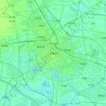
Name: Topografische Karte Tianjin, Höhe, Relief.
Ort: Tianjin, Heping District, Tianjin, 300050, China (38.95755 117.03130 39.27755 117.35130)
Durchschnittliche Höhe: 5 m
Minimale Höhe: -5 m
Maximale Höhe: 21 m
Andere topografische Karten
Klicken Sie auf eine Karte, um ihre Topografie, ihre Höhe und ihr Relief anzuzeigen.





Nankai District
Nankai District is located in the south-west corner of the urban Tianjin, bordered by Hongqiao District to the north, Hebei and Heping Districts to the north-east, Hexi District to the east and Xiqing District to the south-west. It occupies an area of 40.64 square kilometres (15.69 sq mi). The natural…
Durchschnittliche Höhe: 6 m