
Spenden
Rüste dich für dein nächstes Abenteuer:
Als Amazon-Partner verdient diese Seite an qualifizierten Käufen, ohne dass Ihnen zusätzliche Kosten entstehen.
Topografische Karte les Preses
Klicken Sie auf die Karte, um die Höhe anzuzeigen.
Spenden
Rüste dich für dein nächstes Abenteuer:
Als Amazon-Partner verdient diese Seite an qualifizierten Käufen, ohne dass Ihnen zusätzliche Kosten entstehen.
Über diese Karte
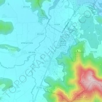
Name: Topografische Karte les Preses, Höhe, Relief.
Ort: les Preses, Garrotxa, Gerona, Cataluña, 17178, España (42.12923 2.45365 42.16867 2.49816)
Durchschnittliche Höhe: 520 m
Minimale Höhe: 439 m
Maximale Höhe: 914 m
Spenden
Rüste dich für dein nächstes Abenteuer:
Als Amazon-Partner verdient diese Seite an qualifizierten Käufen, ohne dass Ihnen zusätzliche Kosten entstehen.
Andere topografische Karten
Klicken Sie auf eine Karte, um ihre Topografie, ihre Höhe und ihr Relief anzuzeigen.
Castellfollit de la Roca
España > Cataluña > Garrotxa > Castellfollit de la Roca > Castellfollit de la Roca
Durchschnittliche Höhe: 394 m
Puigsacalm
España > Cataluña > Garrotxa > la Vall d'en Bas
El Puigsacalm es una montaña de 1515 metros de altitud que se encuentra en el municipio de la Vall de Bas, en la comarca de La Garrocha (Cataluña, España). Es el punto más alto de la cordillera Transversal.
Durchschnittliche Höhe: 1’117 m
Santa Margarida de Bianya
España > Cataluña > Garrotxa > la Vall de Bianya > l'Hostalnou de Bianya
Durchschnittliche Höhe: 467 m
Spenden
Rüste dich für dein nächstes Abenteuer:
Als Amazon-Partner verdient diese Seite an qualifizierten Käufen, ohne dass Ihnen zusätzliche Kosten entstehen.
Spenden
Rüste dich für dein nächstes Abenteuer:
Als Amazon-Partner verdient diese Seite an qualifizierten Käufen, ohne dass Ihnen zusätzliche Kosten entstehen.
Reserva natural parcial de Turó de la Pomareda
España > Cataluña > Garrotxa > Olot
Durchschnittliche Höhe: 626 m
Spenden
Rüste dich für dein nächstes Abenteuer:
Als Amazon-Partner verdient diese Seite an qualifizierten Käufen, ohne dass Ihnen zusätzliche Kosten entstehen.
Volcán de Santa Margarita
España > Cataluña > Garrotxa > Santa Pau
Es uno de los más importantes del sector, de 682 metros de altitud y su boca tiene un perímetro de 2000 metros. En el centro del llano formado por el cráter se encuentra la iglesia de Santa Margarita, de origen románico. Su última erupción data de hace 11 000 años.
Durchschnittliche Höhe: 640 m
Spenden
Rüste dich für dein nächstes Abenteuer:
Als Amazon-Partner verdient diese Seite an qualifizierten Käufen, ohne dass Ihnen zusätzliche Kosten entstehen.