
Topografische Karte Łódź
Interaktive Karte
Klicken Sie auf die Karte, um die Höhe anzuzeigen.
Über diese Karte
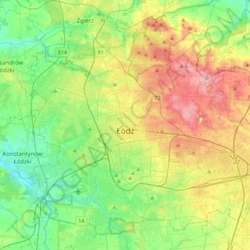
Name: Topografische Karte Łódź, Höhe, Relief.
Ort: Łódź, Łódź Voivodeship, Poland (51.68614 19.32086 51.85983 19.63994)
Durchschnittliche Höhe: 203 m
Minimale Höhe: 158 m
Maximale Höhe: 281 m
Łódź covers an area of approximately 293 square kilometres (113 sq mi) and is located in the centre of Poland. The city lies in the lowlands of the Central European Plain, not exceeding 300 metres in elevation. Topographically, the Łódź region is generally characterised by a flat landscape, with only several highlands which do not exceed 50 metres above the terrain level. The soil is predominantly sandy (62%) followed by clay (24%), silt (8%), and organogenic formations (6%) from regional wetlands. The forest cover (equivalent to 4.2% of the whole country) is considerably low compared to other cities, regions, and provinces of Poland.
Andere topografische Karten
Klicken Sie auf eine Karte, um ihre Topografie, ihre Höhe und ihr Relief anzuzeigen.
Kutno
Poland > Łódź Voivodeship > Kutno County > Kutno
Kutno, Kutno County, Łódź Voivodeship, Poland
Durchschnittliche Höhe: 114 m
Radomsko
Radomsko, powiat radomszczański, Łódź Voivodeship, Poland
Durchschnittliche Höhe: 232 m
Witonia
Poland > Łódź Voivodeship > Witonia
Witonia, gmina Witonia, powiat łęczycki, Łódź Voivodeship, 99-335, Poland
Durchschnittliche Höhe: 110 m
Czarnów
Poland > Łódź Voivodeship > Kutno County
Czarnów, gmina Bedlno, Kutno County, Łódź Voivodeship, Poland
Durchschnittliche Höhe: 106 m
Radomsko
Poland > Łódź Voivodeship > Radomsko
Radomsko, powiat radomszczański, Łódź Voivodeship, Poland
Durchschnittliche Höhe: 231 m
Skierniewice
Skierniewice, Łódź Voivodeship, 96-100, Poland
Durchschnittliche Höhe: 127 m
Zgierz
Poland > Łódź Voivodeship > Zgierz
Zgierz, Zgierz County, Łódź Voivodeship, 95-100, Poland
Durchschnittliche Höhe: 193 m