
Topografische Karte Martinsville
Interaktive Karte
Klicken Sie auf die Karte, um die Höhe anzuzeigen.
Über diese Karte
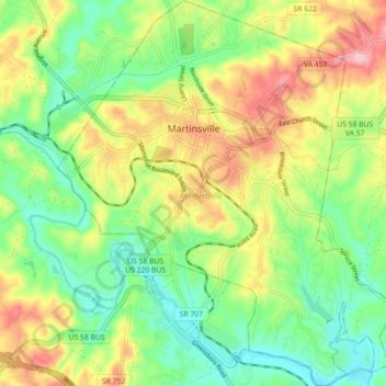
Name: Topografische Karte Martinsville, Höhe, Relief.
Ort: Martinsville, Martinsville City, Virginia, United States (36.64381 -79.90408 36.71534 -79.82626)
Durchschnittliche Höhe: 259 m
Minimale Höhe: 194 m
Maximale Höhe: 355 m
According to the United States Census Bureau, the city has a total area of 11.0 square miles (28.5 km2), of which 11.0 square miles (28.5 km2) is land and 0.1 square miles (0.3 km2) (0.5%) is water. The north side of the city has the highest average elevation. The east side slopes gradually down to the Smith River on the south side. The west side is hilly. Martinsville is located on the southern border of Southern Virginia.