
Topografische Karte Hollidaysburg
Interaktive Karte
Klicken Sie auf die Karte, um die Höhe anzuzeigen.
Über diese Karte
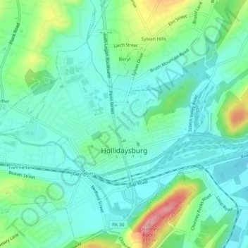
Name: Topografische Karte Hollidaysburg, Höhe, Relief.
Ort: Hollidaysburg, Blair County, Pennsylvania, United States (40.41856 -78.41695 40.45027 -78.37201)
Durchschnittliche Höhe: 311 m
Minimale Höhe: 277 m
Maximale Höhe: 410 m
Andere topografische Karten
Klicken Sie auf eine Karte, um ihre Topografie, ihre Höhe und ihr Relief anzuzeigen.
Mill Run
United States > Pennsylvania > Blair County > Altoona > Allegheny Furnace
Mill Run, Allegheny Furnace, Altoona, Blair County, Pennsylvania, 16603, United States
Durchschnittliche Höhe: 349 m
Pinecroft
United States > Pennsylvania > Blair County > Antis Township
Pinecroft, Antis Township, Blair County, Pennsylvania, 16617, United States
Durchschnittliche Höhe: 354 m
Calvert Hills
United States > Pennsylvania > Blair County > Altoona
Calvert Hills, Altoona, Blair County, Pennsylvania, 16601, United States
Durchschnittliche Höhe: 412 m
Roaring Spring
United States > Pennsylvania > Blair County
Roaring Spring, Blair County, Pennsylvania, United States
Durchschnittliche Höhe: 396 m
Tyrone
United States > Pennsylvania > Blair County > Tyrone
Tyrone, Blair County, Pennsylvania, United States
Durchschnittliche Höhe: 341 m
Mill Run
United States > Pennsylvania > Blair County > Altoona > Llyswen
Mill Run, Llyswen, Altoona, Blair County, Pennsylvania, United States
Durchschnittliche Höhe: 340 m
Greenwood
United States > Pennsylvania > Blair County > Logan Township > Greenwood
Greenwood, Logan Township, Blair County, Pennsylvania, 166602, United States
Durchschnittliche Höhe: 426 m
Altoona
United States > Pennsylvania > Blair County
Altoona, Blair County, Pennsylvania, United States
Durchschnittliche Höhe: 443 m
Mill Run
United States > Pennsylvania > Blair County > Logan Township
Mill Run, Logan Township, Blair County, Pennsylvania, 16603, United States
Durchschnittliche Höhe: 443 m