
Topografische Karte Bukowina Tatrzańska
Interaktive Karte
Klicken Sie auf die Karte, um die Höhe anzuzeigen.
Über diese Karte
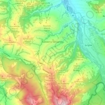
Name: Topografische Karte Bukowina Tatrzańska, Höhe, Relief.
Durchschnittliche Höhe: 886 m
Minimale Höhe: 718 m
Maximale Höhe: 1’147 m
Andere topografische Karten
Klicken Sie auf eine Karte, um ihre Topografie, ihre Höhe und ihr Relief anzuzeigen.
Zakopane
Poland > Lesser Poland Voivodeship > Tatra County
Zakopane, Tatra County, Lesser Poland Voivodeship, Poland
Durchschnittliche Höhe: 1’180 m
Wielki Giewont
Poland > Lesser Poland Voivodeship > Tatra County > Zakopane
Wielki Giewont, Zakopane, Tatra County, Lesser Poland Voivodeship, Poland
Durchschnittliche Höhe: 1’478 m
Sarnia Skała
Poland > Lesser Poland Voivodeship > Tatra County > Zakopane
Sarnia Skała, Zakopane, Tatra County, Lesser Poland Voivodeship, 34-500, Poland
Durchschnittliche Höhe: 1’206 m
Tatry
Poland > Lesser Poland Voivodeship > Tatra County > Zakopane
Tatry, Zakopane, Tatra County, Lesser Poland Voivodeship, Poland
Durchschnittliche Höhe: 1’647 m
Zakopane
Poland > Lesser Poland Voivodeship > Tatra County
Zakopane, Tatra County, Lesser Poland Voivodeship, Poland
Durchschnittliche Höhe: 1’180 m