
Spenden
Rüste dich für dein nächstes Abenteuer:
Als Amazon-Partner verdient diese Seite an qualifizierten Käufen, ohne dass Ihnen zusätzliche Kosten entstehen.
Topografische Karte Windsor
Klicken Sie auf die Karte, um die Höhe anzuzeigen.
Spenden
Rüste dich für dein nächstes Abenteuer:
Als Amazon-Partner verdient diese Seite an qualifizierten Käufen, ohne dass Ihnen zusätzliche Kosten entstehen.
Windsor
Some days in the winter and spring can be warm and extremely dry, with Chinook winds often raising temperatures to near 70 °F (21 °C) in January and February, and sometimes to near 90 °F (32 °C) in April. Windsor's elevation and low year-round humidity means that nighttime low temperatures are practically never above 68 °F (20 °C), even in the very hottest part of the summer. The diurnal temperature range is usually rather wide, with a 50-degree (Fahrenheit) difference between daytime high and nighttime low not uncommon, especially in the spring and fall months. Rapid fluctuation in temperature is also common – a sunny 80 °F (27 °C) October afternoon can easily give way to a 28 °F (-2 °C) blizzard within 12 hours.
Spenden
Rüste dich für dein nächstes Abenteuer:
Als Amazon-Partner verdient diese Seite an qualifizierten Käufen, ohne dass Ihnen zusätzliche Kosten entstehen.
Über diese Karte
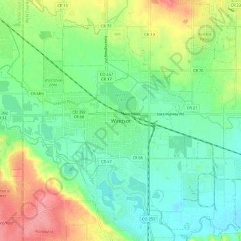
Name: Topografische Karte Windsor, Höhe, Relief.
Ort: Windsor, Weld County, Colorado, 80550-5129, United States (40.43748 -104.94136 40.51748 -104.86136)
Durchschnittliche Höhe: 1’471 m
Minimale Höhe: 1’441 m
Maximale Höhe: 1’527 m
Spenden
Rüste dich für dein nächstes Abenteuer:
Als Amazon-Partner verdient diese Seite an qualifizierten Käufen, ohne dass Ihnen zusätzliche Kosten entstehen.