
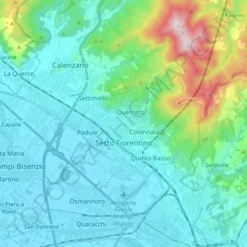
Topografische Karte Sesto Fiorentino
Interaktive Karte
Klicken Sie auf die Karte, um die Höhe anzuzeigen.
Über diese Karte
Name: Topografische Karte Sesto Fiorentino, Höhe, Relief.
Durchschnittliche Höhe: 187 m
Minimale Höhe: 30 m
Maximale Höhe: 925 m
Andere topografische Karten
Klicken Sie auf eine Karte, um ihre Topografie, ihre Höhe und ihr Relief anzuzeigen.
Florence
Italy > Tuscany > Metropolitan City of Florence > Florence
Florence, Metropolitan City of Florence, Tuscany, 50100, Italy
Durchschnittliche Höhe: 238 m
Impruneta
Italy > Tuscany > Metropolitan City of Florence
Impruneta, Metropolitan City of Florence, Tuscany, 50023, Italy
Durchschnittliche Höhe: 173 m
Londa
Italy > Tuscany > Metropolitan City of Florence
Londa, Metropolitan City of Florence, Tuscany, Italy
Durchschnittliche Höhe: 574 m
Rufina
Italy > Tuscany > Metropolitan City of Florence
Rufina, Metropolitan City of Florence, Tuscany, Italy
Durchschnittliche Höhe: 396 m
Due Strade
Italy > Tuscany > Metropolitan City of Florence > Florence
Due Strade, Quartiere 3, Florence, Metropolitan City of Florence, Tuscany, 50124, Italy
Durchschnittliche Höhe: 93 m
Morrocco
Italy > Tuscany > Metropolitan City of Florence > Sambuca
Morrocco, Sambuca, Barberino Tavarnelle, Metropolitan City of Florence, Tuscany, 50028, Italy
Durchschnittliche Höhe: 288 m
Pontassieve
Italy > Tuscany > Metropolitan City of Florence > Pontassieve
Pontassieve, Metropolitan City of Florence, Tuscany, 50065, Italy
Durchschnittliche Höhe: 364 m