
Topografische Karte Drăgănești-Olt
Interaktive Karte
Klicken Sie auf die Karte, um die Höhe anzuzeigen.
Über diese Karte
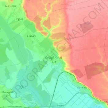
Name: Topografische Karte Drăgănești-Olt, Höhe, Relief.
Ort: Drăgănești-Olt, Olt, Romania (44.12293 24.46656 44.22532 24.61533)
Durchschnittliche Höhe: 101 m
Minimale Höhe: 59 m
Maximale Höhe: 148 m
The town is situated on the Wallachian Plain. It lies on the left bank of the river Olt, at an altitude of approximately 100 m (330 ft). It is located in the central part of Olt County, at a distance of 35 km (22 mi) from the county seat, Slatina, and 65 km (40 mi) north of Turnu Măgurele.
Andere topografische Karten
Klicken Sie auf eine Karte, um ihre Topografie, ihre Höhe und ihr Relief anzuzeigen.
Vitomirești
Romania > Olt > Vitomirești
Vitomirești, Olt, 237545, Romania
Durchschnittliche Höhe: 363 m