
Topografische Karte Tigard
Interaktive Karte
Klicken Sie auf die Karte, um die Höhe anzuzeigen.
Über diese Karte
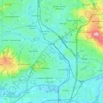
Name: Topografische Karte Tigard, Höhe, Relief.
Ort: Tigard, Washington County, Oregon, United States (45.39324 -122.85692 45.45643 -122.74342)
Durchschnittliche Höhe: 83 m
Minimale Höhe: 31 m
Maximale Höhe: 288 m
Andere topografische Karten
Klicken Sie auf eine Karte, um ihre Topografie, ihre Höhe und ihr Relief anzuzeigen.
Vern Galaway Memorial Park
United States > Oregon > Washington County > North Plains
Vern Galaway Memorial Park, North Plains, Washington County, Oregon, United States
Durchschnittliche Höhe: 56 m
Tualatin
United States > Oregon > Washington County
Tualatin, Washington County, Oregon, 97062, United States
Durchschnittliche Höhe: 70 m
Beaverton
United States > Oregon > Washington County
Beaverton, Washington County, Oregon, United States
Durchschnittliche Höhe: 106 m
Cornelius
United States > Oregon > Washington County > Cornelius
Cornelius, Washington County, Oregon, United States
Durchschnittliche Höhe: 51 m
Banks
United States > Oregon > Washington County
Banks, Washington County, Oregon, 97106, United States
Durchschnittliche Höhe: 70 m
Hillsboro
United States > Oregon > Washington County
Hillsboro, Washington County, Oregon, United States
Durchschnittliche Höhe: 53 m