
Spenden
Rüste dich für dein nächstes Abenteuer:
Als Amazon-Partner verdient diese Seite an qualifizierten Käufen, ohne dass Ihnen zusätzliche Kosten entstehen.
Topografische Karte Hinsdale
Klicken Sie auf die Karte, um die Höhe anzuzeigen.
Spenden
Rüste dich für dein nächstes Abenteuer:
Als Amazon-Partner verdient diese Seite an qualifizierten Käufen, ohne dass Ihnen zusätzliche Kosten entstehen.
Hinsdale
Hinsdale is a village in Cook and DuPage counties in the U.S. state of Illinois. Hinsdale is a western suburb of Chicago. The population was 16,816 at the 2010 census, most of whom lived in DuPage County. The town's ZIP code is 60521, which is listed in the top 1% of wealthiest towns in Illinois as well as the sixth-wealthiest ZIP code in the United States among areas with a population of 20,000 or more. The town has a rolling, wooded topography, with a downtown, and is a 22-minute express train ride to downtown Chicago on the Burlington Northern line.
Spenden
Rüste dich für dein nächstes Abenteuer:
Als Amazon-Partner verdient diese Seite an qualifizierten Käufen, ohne dass Ihnen zusätzliche Kosten entstehen.
Über diese Karte
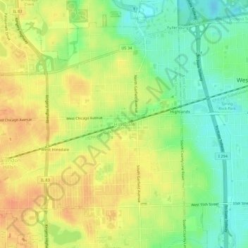
Name: Topografische Karte Hinsdale, Höhe, Relief.
Ort: Hinsdale, DuPage County, Illinois, 60521, United States (41.78246 -87.94998 41.82246 -87.90998)
Durchschnittliche Höhe: 214 m
Minimale Höhe: 192 m
Maximale Höhe: 232 m
Spenden
Rüste dich für dein nächstes Abenteuer:
Als Amazon-Partner verdient diese Seite an qualifizierten Käufen, ohne dass Ihnen zusätzliche Kosten entstehen.