
Topografische Karte Sankt Andreasberg
Interaktive Karte
Klicken Sie auf die Karte, um die Höhe anzuzeigen.
Über diese Karte
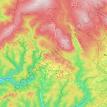
Name: Topografische Karte Sankt Andreasberg, Höhe, Relief.
Durchschnittliche Höhe: 648 m
Minimale Höhe: 347 m
Maximale Höhe: 914 m
As a result of their elevation, Sankt Andreasberg (520–720 m) and Sonnenberg (800–850 m) still have fairly guaranteed snow. Sankt Andreasberg is an Alpine Ski Centre of the Harz, with three T-bar lifts on the Sonnenberg as well as two double chair lifts and three T-bars at the Matthias Schmidt Mountain Centre. In the Teichtal there is the first snowtubing track in the Harz. The cross-country skiing trail network around Sankt Andreasberg has 40 km of tracks and is linked from the Sonnenberg to Oderbrück/Torfhaus and to the Ackerloipe/Altenau networks. On Matthias Schmidt Mountain a Sommerrodelbahn is open during the summer. Nordic Walking, hiking, mountain biking and trekking are popular summer activities in the peaceful surroundings of the Sankt Andreasberg mountain town. In the spa park there is a ropes course and climbing park. The southern part of the Oderteich reservoir in the Harz National Park is open to swimmers in the summer.
Andere topografische Karten
Klicken Sie auf eine Karte, um ihre Topografie, ihre Höhe und ihr Relief anzuzeigen.
Hohegeiß
Germany > Lower Saxony > Landkreis Goslar > Braunlage
Hohegeiß, Braunlage, Landkreis Goslar, Lower Saxony, Germany
Durchschnittliche Höhe: 568 m