
Topografische Karte Monte Rio
Interaktive Karte
Klicken Sie auf die Karte, um die Höhe anzuzeigen.
Über diese Karte
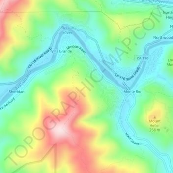
Name: Topografische Karte Monte Rio, Höhe, Relief.
Ort: Monte Rio, Sonoma County, California, 95486, United States (38.45577 -123.03198 38.47698 -122.99132)
Durchschnittliche Höhe: 131 m
Minimale Höhe: -1 m
Maximale Höhe: 378 m
Andere topografische Karten
Klicken Sie auf eine Karte, um ihre Topografie, ihre Höhe und ihr Relief anzuzeigen.
Larkfield-Wikiup
United States > California > Sonoma County
Larkfield-Wikiup, Sonoma County, California, United States
Durchschnittliche Höhe: 90 m
Glen Ellen
United States > California > Sonoma County
Glen Ellen, Sonoma County, California, United States
Durchschnittliche Höhe: 188 m
Howarth Memorial Park
United States > California > Sonoma County > Santa Rosa
Howarth Memorial Park, Santa Rosa, Sonoma County, California, 95405, United States
Durchschnittliche Höhe: 81 m
Bald Hills
United States > California > Sonoma County
Bald Hills, Sonoma County, California, United States
Durchschnittliche Höhe: 250 m
Geyserville
United States > California > Sonoma County
Geyserville, Sonoma County, California, 95441, United States
Durchschnittliche Höhe: 103 m
Santa Rosa
United States > California > Sonoma County
Santa Rosa, Sonoma County, CAL Fire Northern Region, California, United States
Durchschnittliche Höhe: 136 m