
Spenden
Rüste dich für dein nächstes Abenteuer:
Als Amazon-Partner verdient diese Seite an qualifizierten Käufen, ohne dass Ihnen zusätzliche Kosten entstehen.
Topografische Karte Hakalau
Klicken Sie auf die Karte, um die Höhe anzuzeigen.
Spenden
Rüste dich für dein nächstes Abenteuer:
Als Amazon-Partner verdient diese Seite an qualifizierten Käufen, ohne dass Ihnen zusätzliche Kosten entstehen.
Über diese Karte
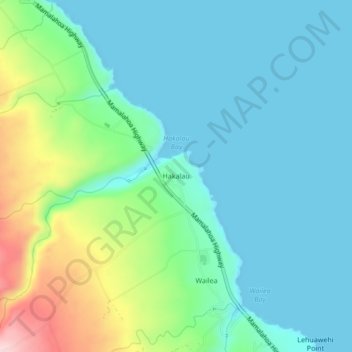
Name: Topografische Karte Hakalau, Höhe, Relief.
Ort: Hakalau, Hawaiʻi County, Hawaii, 96710, United States (19.87783 -155.14695 19.91783 -155.10695)
Durchschnittliche Höhe: 60 m
Minimale Höhe: 0 m
Maximale Höhe: 258 m
Spenden
Rüste dich für dein nächstes Abenteuer:
Als Amazon-Partner verdient diese Seite an qualifizierten Käufen, ohne dass Ihnen zusätzliche Kosten entstehen.
Andere topografische Karten
Klicken Sie auf eine Karte, um ihre Topografie, ihre Höhe und ihr Relief anzuzeigen.
Captain Cook
United States > Hawaii > Hawaiʻi County
Most of Captain Cook lies between the 800-foot (240 m) and 2,000-foot (610 m) elevation, which makes it ideal as a coffee-growing region. It sits on the top of an ancient fault which created the famous Kealakekua Bay. Prior to the 1960s, most of Captain Cook was part of the vast Kealakekua Ranch, founded in…
Durchschnittliche Höhe: 373 m
Hilo
United States > Hawaii > Hawaiʻi County
Hilo has a tropical rainforest climate (Köppen Af), with substantial rainfall throughout the year. Its location on the windward coast (relative to the trade winds), makes it the fourth-wettest city in the United States, behind the southeast Alaskan cities of Whittier, Ketchikan and Yakutat, and one of the…
Durchschnittliche Höhe: 193 m
Spenden
Rüste dich für dein nächstes Abenteuer:
Als Amazon-Partner verdient diese Seite an qualifizierten Käufen, ohne dass Ihnen zusätzliche Kosten entstehen.
Volcano
United States > Hawaii > Hawaiʻi County
Owing to its altitude, ranging from below 2,800 feet (850 m) in the southeast to over 6,200 feet (1,900 m) at its uninhabited northern end, Volcano features a subtropical highland climate (Köppen Cfb), with relatively uniform temperatures and abundant rainfall throughout the year, although rainfall is…
Durchschnittliche Höhe: 1’219 m
Hawaiian Ocean View
United States > Hawaii > Hawaiʻi County
The HOVE development consisted of 10,697 1-acre (4,000 m2) lots north of the Hawaii Belt Road in the western part of the District of Kaʻū. The terrain varies from rugged lava fields to ohiʻa trees and other vegetation. Elevation ranges from about 1,500 ft (460 m) up to the 5,000-foot (1,500 m) level.…
Durchschnittliche Höhe: 723 m
Spenden
Rüste dich für dein nächstes Abenteuer:
Als Amazon-Partner verdient diese Seite an qualifizierten Käufen, ohne dass Ihnen zusätzliche Kosten entstehen.
Spenden
Rüste dich für dein nächstes Abenteuer:
Als Amazon-Partner verdient diese Seite an qualifizierten Käufen, ohne dass Ihnen zusätzliche Kosten entstehen.
Waimea/Kamuela
United States > Hawaii > Hawaiʻi County
Waimea is located in the northern part of the island of Hawaii at 20°1′26″N 155°38′50″W / 20.02389°N 155.64722°W / 20.02389; -155.64722 (20.023926, -155.647357), at an elevation of 2,676 feet (816 m) above sea level. It sits at the southern foot of Kohala, the oldest volcano on the island,…
Durchschnittliche Höhe: 876 m
Spenden
Rüste dich für dein nächstes Abenteuer:
Als Amazon-Partner verdient diese Seite an qualifizierten Käufen, ohne dass Ihnen zusätzliche Kosten entstehen.
Hawaiian Ocean View
United States > Hawaii > Hawaiʻi County
The HOVE development consisted of 10,697 1-acre (4,000 m2) lots north of the Hawaii Belt Road in the western part of the District of Kaʻū. The terrain varies from rugged lava fields to ohiʻa trees and other vegetation. Elevation ranges from about 1,500 ft (460 m) up to the 5,000-foot (1,500 m) level.…
Durchschnittliche Höhe: 723 m
Hilo
United States > Hawaii > Hawaiʻi County
Hilo has a tropical rainforest climate (Köppen Af), with substantial rainfall throughout the year. Its location on the windward coast (relative to the trade winds), makes it the fourth-wettest city in the United States, behind the southeast Alaskan cities of Whittier, Ketchikan and Yakutat, and one of the…
Durchschnittliche Höhe: 193 m
Spenden
Rüste dich für dein nächstes Abenteuer:
Als Amazon-Partner verdient diese Seite an qualifizierten Käufen, ohne dass Ihnen zusätzliche Kosten entstehen.
Volcano
United States > Hawaii > Hawaiʻi County
Its altitude ranges from below 2,800 feet (850 m) in the southeast to over 6,200 feet (1,900 m) at its uninhabited northern end. Due to this, Volcano features a subtropical highland climate (Köppen Cfb), with relatively uniform temperatures and abundant rainfall throughout the year, although rainfall is…
Durchschnittliche Höhe: 1’219 m
Captain Cook
United States > Hawaii > Hawaiʻi County
Most of Captain Cook lies between the 800-foot (240 m) and 2,000-foot (610 m) elevation, which makes it ideal as a coffee-growing region. It sits on the top of an ancient fault which created the famous Kealakekua Bay. Prior to the 1960s, most of Captain Cook was part of the vast Kealakekua Ranch, founded in…
Durchschnittliche Höhe: 425 m
Spenden
Rüste dich für dein nächstes Abenteuer:
Als Amazon-Partner verdient diese Seite an qualifizierten Käufen, ohne dass Ihnen zusätzliche Kosten entstehen.
Spenden
Rüste dich für dein nächstes Abenteuer:
Als Amazon-Partner verdient diese Seite an qualifizierten Käufen, ohne dass Ihnen zusätzliche Kosten entstehen.
Hilo
United States > Hawaii > Hawaiʻi County
Hilo has a tropical rainforest climate (Köppen: Af), with substantial rainfall throughout the year. Its location on the windward coast (relative to the trade winds), makes it the fourth-wettest city in the United States, behind the southeast Alaskan cities of Whittier, Ketchikan and Yakutat, and one of the…
Durchschnittliche Höhe: 193 m
Waimea/Kamuela
United States > Hawaii > Hawaiʻi County
Waimea is located in the northern part of the island of Hawaii at an elevation of 2,676 feet (816 m) above sea level. It sits at the southern foot of Kohala, the oldest volcano on the island, and it is near the northwestern base of Mauna Kea, the highest volcano.
Durchschnittliche Höhe: 897 m
Spenden
Rüste dich für dein nächstes Abenteuer:
Als Amazon-Partner verdient diese Seite an qualifizierten Käufen, ohne dass Ihnen zusätzliche Kosten entstehen.
Volcano
United States > Hawaii > Hawaiʻi County
Its altitude ranges from below 2,800 feet (850 m) in the southeast to over 6,200 feet (1,900 m) at its uninhabited northern end. Due to this, Volcano features a subtropical highland climate (Köppen Cfb), with relatively uniform temperatures and abundant rainfall throughout the year, although rainfall is…
Durchschnittliche Höhe: 1’219 m
Hilo
United States > Hawaii > Hawaiʻi County
Hilo has a tropical rainforest climate (Köppen: Af), with substantial rainfall throughout the year. Its location on the windward coast (relative to the trade winds), makes it the fourth-wettest city in the United States, behind the southeast Alaskan cities of Whittier, Ketchikan and Yakutat, and one of the…
Durchschnittliche Höhe: 258 m
Waimea/Kamuela
United States > Hawaii > Hawaiʻi County
Waimea is located in the northern part of the island of Hawaii at an elevation of 2,676 feet (816 m) above sea level. It sits at the southern foot of Kohala, the oldest volcano on the island, and it is near the northwestern base of Mauna Kea, the highest volcano.
Durchschnittliche Höhe: 876 m
Spenden
Rüste dich für dein nächstes Abenteuer:
Als Amazon-Partner verdient diese Seite an qualifizierten Käufen, ohne dass Ihnen zusätzliche Kosten entstehen.
Hilo
United States > Hawaii > Hawaiʻi County
Hilo has a tropical rainforest climate (Köppen: Af), with substantial rainfall throughout the year. Its location on the windward coast (relative to the trade winds), makes it the fourth-wettest city in the United States, behind the southeast Alaskan cities of Whittier, Ketchikan and Yakutat, and one of the…
Durchschnittliche Höhe: 193 m
Volcano
United States > Hawaii > Hawaiʻi County
Its altitude ranges from below 2,800 feet (850 m) in the southeast to over 6,200 feet (1,900 m) at its uninhabited northern end. Due to this, Volcano features a subtropical highland climate (Köppen Cfb), with relatively uniform temperatures and abundant rainfall throughout the year, although rainfall is…
Durchschnittliche Höhe: 1’111 m
Volcano
United States > Hawaii > Hawaiʻi County
Its altitude ranges from below 2,800 feet (850 m) in the southeast to over 6,200 feet (1,900 m) at its uninhabited northern end. Due to this, Volcano features a subtropical highland climate (Köppen Cfb), with relatively uniform temperatures and abundant rainfall throughout the year, although rainfall is…
Durchschnittliche Höhe: 1’219 m
Spenden
Rüste dich für dein nächstes Abenteuer:
Als Amazon-Partner verdient diese Seite an qualifizierten Käufen, ohne dass Ihnen zusätzliche Kosten entstehen.
Waimea/Kamuela
United States > Hawaii > Hawaiʻi County
Waimea is located in the northern part of the island of Hawaii at 20°1′26″N 155°38′50″W / 20.02389°N 155.64722°W / 20.02389; -155.64722 (20.023926, -155.647357), at an elevation of 2,676 feet (816 m) above sea level. It sits at the southern foot of Kohala, the oldest volcano on the island,…
Durchschnittliche Höhe: 876 m
Spenden
Rüste dich für dein nächstes Abenteuer:
Als Amazon-Partner verdient diese Seite an qualifizierten Käufen, ohne dass Ihnen zusätzliche Kosten entstehen.