
Topografische Karte Granite Peak
Interaktive Karte
Klicken Sie auf die Karte, um die Höhe anzuzeigen.
Über diese Karte
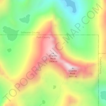
Name: Topografische Karte Granite Peak, Höhe, Relief.
Ort: Granite Peak, Park County, Montana, United States (45.16720 -109.81461 45.16730 -109.81451)
Durchschnittliche Höhe: 3’395 m
Minimale Höhe: 2’966 m
Maximale Höhe: 3’894 m
Andere topografische Karten
Klicken Sie auf eine Karte, um ihre Topografie, ihre Höhe und ihr Relief anzuzeigen.
Wilsall
United States > Montana > Park County
Wilsall, Park County, Montana, 59086, United States
Durchschnittliche Höhe: 1’550 m
Livingston
United States > Montana > Park County
Livingston, Park County, Montana, United States
Durchschnittliche Höhe: 1’421 m
Gardiner
United States > Montana > Park County
Gardiner, Park County, Montana, United States
Durchschnittliche Höhe: 1’866 m
Cooke City
United States > Montana > Park County
Cooke City, Park County, Montana, 59020, United States
Durchschnittliche Höhe: 2’574 m
Jardine
United States > Montana > Park County > Jardine
Jardine, Park County, Montana, United States
Durchschnittliche Höhe: 2’198 m
Granite Peak
United States > Montana > Park County
Granite Peak, Park County, Montana, United States
Durchschnittliche Höhe: 2’660 m
Emigrant
United States > Montana > Park County
Emigrant, Park County, Montana, 59027, United States
Durchschnittliche Höhe: 1’530 m
Corwin Springs
United States > Montana > Park County
Corwin Springs, Park County, Montana, United States
Durchschnittliche Höhe: 1’809 m