
Topografische Karte Devils Tower
Interaktive Karte
Klicken Sie auf die Karte, um die Höhe anzuzeigen.
Über diese Karte
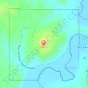
Name: Topografische Karte Devils Tower, Höhe, Relief.
Durchschnittliche Höhe: 1’236 m
Minimale Höhe: 1’170 m
Maximale Höhe: 1’547 m
Andere topografische Karten
Klicken Sie auf eine Karte, um ihre Topografie, ihre Höhe und ihr Relief anzuzeigen.
Yellowstone Caldera Supervolcano
United States of America > Wyoming
Yellowstone Caldera Supervolcano, Teton County, Wyoming, United States of America
Durchschnittliche Höhe: 2’530 m
Wind River Range
United States of America > Wyoming
Wind River Range, Fremont County, Wyoming, United States of America
Durchschnittliche Höhe: 3’706 m
Cedar Rim
United States of America > Wyoming > Riverton
Cedar Rim, Sand Draw Road, Riverton, Fremont County, Wyoming, United States of America
Durchschnittliche Höhe: 2’131 m
Upton
United States of America > Wyoming > Upton
Upton, Weston County, Wyoming, United States of America
Durchschnittliche Höhe: 1’301 m
Red Butte
United States of America > Wyoming > Red Butte
Red Buttes Village, Red Butte, Natrona County, Wyoming, 82604, United States of America
Durchschnittliche Höhe: 1’605 m
Shoshone Geyser
United States of America > Wyoming
Shoshone Geyser, Shoshone Lake, Teton County, Wyoming, United States of America
Durchschnittliche Höhe: 2’416 m
Opal
United States of America > Wyoming > Opal
Opal, Lincoln County, Wyoming, United States of America
Durchschnittliche Höhe: 2’048 m
Phelps Lake
United States of America > Wyoming > Teton Village
Phelps Lake, Aspen Ridge Trail, Teton Village, Teton County, Wyoming, 83025, United States of America
Durchschnittliche Höhe: 2’084 m