
Topografische Karte Antlers
Interaktive Karte
Klicken Sie auf die Karte, um die Höhe anzuzeigen.
Über diese Karte
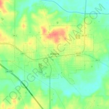
Name: Topografische Karte Antlers, Höhe, Relief.
Ort: Antlers, Pushmataha County, Oklahoma, United States (34.21847 -95.65563 34.24556 -95.60097)
Durchschnittliche Höhe: 154 m
Minimale Höhe: 132 m
Maximale Höhe: 182 m
Andere topografische Karten
Klicken Sie auf eine Karte, um ihre Topografie, ihre Höhe und ihr Relief anzuzeigen.
Finley
United States > Oklahoma > Pushmataha County
Finley, Pushmataha County, Oklahoma, 74543, United States
Durchschnittliche Höhe: 155 m
Nashoba
United States > Oklahoma > Pushmataha County
Nashoba, Pushmataha County, Oklahoma, 74558, United States
Durchschnittliche Höhe: 233 m
Clayton
United States > Oklahoma > Pushmataha County
Clayton, Pushmataha County, Oklahoma, 74536, United States
Durchschnittliche Höhe: 188 m
Albion
United States > Oklahoma > Pushmataha County > Albion
Albion, Pushmataha County, Oklahoma, 74524, United States
Durchschnittliche Höhe: 207 m