Geolokalisieren

Topografische Karte Bee Cave

Klicken Sie auf die Karte, um die Höhe anzuzeigen.

Bee Cave

According to the United States Census Bureau in 2010, the city has a total area of 2.6 square miles (6.7 km2), all of it land. Prior to the 2010 census, Bee Cave went from being a village to being a city, increasing its area to 6.8 square miles (18 km2), all land. It borders Lakeway to the northwest. The landscape of Bee Cave is generally hilly, with elevations ranging from 875 to 1025 feet (265–310 m).

Wikipedia (CC-BY-SA 3.0)

Über diese Karte

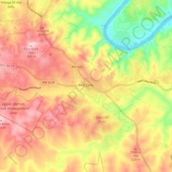
Name: Topografische Karte Bee Cave, Höhe, Relief.

Ort: Bee Cave, Travis County, Texas, United States (30.28614 -98.00369 30.32981 -97.90868)

Durchschnittliche Höhe: 270 m

Minimale Höhe: 148 m

Maximale Höhe: 363 m

Andere topografische Karten

Klicken Sie auf eine Karte, um ihre Topografie, ihre Höhe und ihr Relief anzuzeigen.

Gus Fruh Park

United States > Texas > Travis County > Austin

Durchschnittliche Höhe: 194 m

McKinney Falls State Park

United States > Texas > Travis County > Austin

Durchschnittliche Höhe: 171 m

Mayfield Park

United States > Texas > Travis County > Austin

Durchschnittliche Höhe: 180 m

Onion Creek

United States > Texas > Travis County > Austin

Durchschnittliche Höhe: 162 m

Pilot Knob

United States > Texas > Travis County

Durchschnittliche Höhe: 166 m

East Boggy Creek Greenbelt

United States > Texas > Travis County > Austin

Durchschnittliche Höhe: 144 m

Point Venture

United States > Texas > Travis County > Point Venture

Durchschnittliche Höhe: 227 m

Boggy Creek Greenbelt

United States > Texas > Travis County > Austin

Durchschnittliche Höhe: 158 m

Barton Creek

United States > Texas > Travis County

Durchschnittliche Höhe: 247 m

Austin

United States > Texas > Travis County > Austin

The elevation of Austin varies from 425 feet (130 m) to approximately 1,000 feet (305 m) above sea level. Due to the fact it straddles the Balcones Fault, much of the eastern part of the city is flat, with heavy clay and loam soils, whereas the western part and western suburbs consist of rolling hills on the…

Durchschnittliche Höhe: 203 m

White Rim Mountain

United States > Texas > Travis County

Durchschnittliche Höhe: 259 m

Turkey Creek

United States > Texas > Travis County > Austin

Durchschnittliche Höhe: 198 m

Sprinkle Corner

United States > Texas > Travis County > Austin

Durchschnittliche Höhe: 202 m

Nameless

United States > Texas > Travis County > Leander

Durchschnittliche Höhe: 277 m

Davis Hill

United States > Texas > Travis County > Austin

Durchschnittliche Höhe: 241 m

McKinney Falls State Park

United States > Texas > Travis County > Austin

Durchschnittliche Höhe: 171 m

Barton Creek

United States > Texas > Travis County > Austin

Durchschnittliche Höhe: 155 m

Mount Bonnell

United States > Texas > Travis County > Austin

Durchschnittliche Höhe: 189 m

Canturbury Trails Park

United States > Texas > Travis County > Austin

Durchschnittliche Höhe: 210 m

Steiner Ranch

United States > Texas > Travis County

Durchschnittliche Höhe: 221 m

Mount Lucas

United States > Texas > Travis County > Austin

Durchschnittliche Höhe: 196 m

Pflugerville

United States > Texas > Travis County > Pflugerville > Pflugerville

Durchschnittliche Höhe: 219 m

Rüste dich für dein nächstes Abenteuer:

🔥Campingkocher & Outdoor‑Kocher - Leistungsstarke Kocher für Wander‑ und Trekkingtouren
🔦Stirnlampen - Leistungsstarke Beleuchtung für Wanderungen in der Dämmerung
🥾Wanderschuhe Damen - Komfortable Wanderschuhe mit gutem Grip für lange Wanderungen
🏒Eispickel - Notwendige Sicherheit für winterliche Hochtouren
🩹Blasenpflaster & Fußpflege - Erste Hilfe für Füße bei langen Touren

Als Amazon-Partner verdient diese Seite an qualifizierten Käufen, ohne dass Ihnen zusätzliche Kosten entstehen.