
Spenden
Rüste dich für dein nächstes Abenteuer:
Als Amazon-Partner verdient diese Seite an qualifizierten Käufen, ohne dass Ihnen zusätzliche Kosten entstehen.
Topografische Karte Big Sky
Klicken Sie auf die Karte, um die Höhe anzuzeigen.
Spenden
Rüste dich für dein nächstes Abenteuer:
Als Amazon-Partner verdient diese Seite an qualifizierten Käufen, ohne dass Ihnen zusätzliche Kosten entstehen.
Big Sky
Big Sky is located close to the Yellowstone National Park along the western edge of Gallatin County and eastern edge of Madison County, on U.S. Highway 191. It is approximately midway between West Yellowstone and Bozeman, being around 45 miles (72 km) by road from each. It sits within the Madison Range, with elevations in the CDP ranging from 5,900 feet (1,800 m) in Gallatin Canyon along U.S. 191 to over 11,000 feet (3,400 m) at the summit of Lone Mountain.
Spenden
Rüste dich für dein nächstes Abenteuer:
Als Amazon-Partner verdient diese Seite an qualifizierten Käufen, ohne dass Ihnen zusätzliche Kosten entstehen.
Über diese Karte
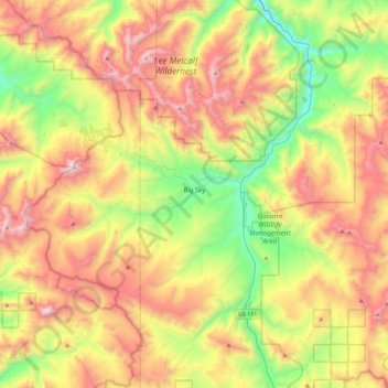
Name: Topografische Karte Big Sky, Höhe, Relief.
Ort: Big Sky, Gallatin County, Montana, United States (45.13076 -111.49439 45.37939 -111.03817)
Durchschnittliche Höhe: 2’439 m
Minimale Höhe: 1’700 m
Maximale Höhe: 3’382 m
Spenden
Rüste dich für dein nächstes Abenteuer:
Als Amazon-Partner verdient diese Seite an qualifizierten Käufen, ohne dass Ihnen zusätzliche Kosten entstehen.
Andere topografische Karten
Klicken Sie auf eine Karte, um ihre Topografie, ihre Höhe und ihr Relief anzuzeigen.
Gallatin Gateway
United States > Montana > Gallatin County
Gallatin Gateway is a census-designated place (CDP) in Gallatin County, Montana, United States. As of the 2020 census, Gallatin Gateway had a population of 967. Elevation is 4,953 ft (1,510 m).
Durchschnittliche Höhe: 1’519 m
Spenden
Rüste dich für dein nächstes Abenteuer:
Als Amazon-Partner verdient diese Seite an qualifizierten Käufen, ohne dass Ihnen zusätzliche Kosten entstehen.
Spenden
Rüste dich für dein nächstes Abenteuer:
Als Amazon-Partner verdient diese Seite an qualifizierten Käufen, ohne dass Ihnen zusätzliche Kosten entstehen.