
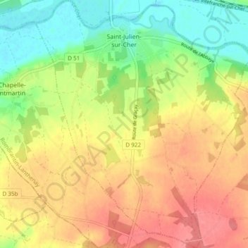
Topografische Karte Saint-Julien-sur-Cher
Interaktive Karte
Klicken Sie auf die Karte, um die Höhe anzuzeigen.
Über diese Karte
Name: Topografische Karte Saint-Julien-sur-Cher, Höhe, Relief.
Durchschnittliche Höhe: 120 m
Minimale Höhe: 81 m
Maximale Höhe: 155 m
L'altitude du territoire communal varie de 82 mètres à 152 mètres.
Andere topografische Karten
Klicken Sie auf eine Karte, um ihre Topografie, ihre Höhe und ihr Relief anzuzeigen.
Fougères-sur-Bièvre
France > Centre-Val de Loire > Loir-et-Cher > Le Controis-en-Sologne
Fougères-sur-Bièvre, Le Controis-en-Sologne, Romorantin-Lanthenay, Loir-et-Cher, Centre-Val de Loire, France métropolitaine, 41120, France
Durchschnittliche Höhe: 97 m
Le Château
France > Centre-Val de Loire > Loir-et-Cher > Chambord
Le Château, Chambord, Blois, Loir-et-Cher, Centre-Val de Loire, France métropolitaine, 41250, France
Durchschnittliche Höhe: 89 m
Château de Ronsard
France > Centre-Val de Loire > Loir-et-Cher > Vallée-de-Ronsard > Couture-sur-Loir > Le Grand Cimetière
Château de Ronsard, Allée de la Pléiade, Le Grand Cimetière, Couture-sur-Loir, Vallée-de-Ronsard, Vendôme, Loir-et-Cher, Centre-Val de Loire, France métropolitaine, 41800, France
Durchschnittliche Höhe: 84 m
Les Rocheuses
France > Centre-Val de Loire > Loir-et-Cher > Villiers-sur-Loir
Les Rocheuses, Villiers-sur-Loir, Vendôme, Loir-et-Cher, Centre-Val de Loire, France métropolitaine, 41100, France
Durchschnittliche Höhe: 95 m
Chaumont-sur-Tharonne
France > Centre-Val de Loire > Loir-et-Cher
Chaumont-sur-Tharonne, Romorantin-Lanthenay, Loir-et-Cher, Centre-Val de Loire, France métropolitaine, 41600, France
Durchschnittliche Höhe: 117 m
Chambord
France > Centre-Val de Loire > Loir-et-Cher
Chambord, Blois, Loir-et-Cher, Centre-Val de Loire, France métropolitaine, 41250, France
Durchschnittliche Höhe: 91 m
Blois
France > Centre-Val de Loire > Loir-et-Cher
Blois, Loir-et-Cher, Centre-Val de Loire, France métropolitaine, 41000, France
Durchschnittliche Höhe: 95 m