
Topografische Karte Charleston
Interaktive Karte
Klicken Sie auf die Karte, um die Höhe anzuzeigen.
Über diese Karte
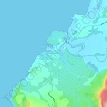
Name: Topografische Karte Charleston, Höhe, Relief.
Ort: Charleston, Buller District, West Coast, New Zealand (-41.92466 171.41717 -41.88466 171.45717)
Durchschnittliche Höhe: 24 m
Minimale Höhe: -1 m
Maximale Höhe: 255 m
Andere topografische Karten
Klicken Sie auf eine Karte, um ihre Topografie, ihre Höhe und ihr Relief anzuzeigen.
Right Branch Maruia River
New Zealand > West Coast > Buller District
Right Branch Maruia River, Buller District, West Coast, New Zealand
Durchschnittliche Höhe: 1’241 m
Waiuta
New Zealand > West Coast > Buller District
Waiuta, Buller District, West Coast, New Zealand
Durchschnittliche Höhe: 417 m
Mokihinui
New Zealand > West Coast > Buller District
Mokihinui, Buller District, West Coast, New Zealand
Durchschnittliche Höhe: 55 m
Granity
New Zealand > West Coast > Buller District
Granity, Buller District, West Coast, New Zealand
Durchschnittliche Höhe: 150 m
Lewis Pass
New Zealand > West Coast > Buller District
Lewis Pass, Buller District, West Coast, New Zealand
Durchschnittliche Höhe: 1’039 m
Cape Foulwind
New Zealand > West Coast > Buller District
Cape Foulwind, Buller District, West Coast, New Zealand
Durchschnittliche Höhe: 14 m
Ikamatua
New Zealand > West Coast > Buller District
Ikamatua, Buller District, West Coast, New Zealand
Durchschnittliche Höhe: 122 m
Hukarere
New Zealand > West Coast > Buller District
Hukarere, Buller District, West Coast, New Zealand
Durchschnittliche Höhe: 131 m
Westport
New Zealand > West Coast > Buller District
Westport, Buller District, West Coast, 7825, New Zealand
Durchschnittliche Höhe: 13 m