
Spenden
Rüste dich für dein nächstes Abenteuer:
Als Amazon-Partner verdient diese Seite an qualifizierten Käufen, ohne dass Ihnen zusätzliche Kosten entstehen.
Topografische Karte Redfish Lake
Klicken Sie auf die Karte, um die Höhe anzuzeigen.
Spenden
Rüste dich für dein nächstes Abenteuer:
Als Amazon-Partner verdient diese Seite an qualifizierten Käufen, ohne dass Ihnen zusätzliche Kosten entstehen.
Redfish Lake
The surface elevation of Redfish Lake is 6,547 feet (1,996 m) above sea level. The lake is 4.5 miles (7.2 km) long and 0.72 miles (1.2 km) wide, with a maximum depth of 387 feet (118 m), and 11 miles (18 km) of shoreline. The actual trail around the lake is 17.5 miles (28 km) in length.
Spenden
Rüste dich für dein nächstes Abenteuer:
Als Amazon-Partner verdient diese Seite an qualifizierten Käufen, ohne dass Ihnen zusätzliche Kosten entstehen.
Über diese Karte
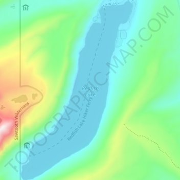
Name: Topografische Karte Redfish Lake, Höhe, Relief.
Ort: Redfish Lake, Custer County, Idaho, United States (44.09323 -114.95587 44.14436 -114.91176)
Durchschnittliche Höhe: 2’144 m
Minimale Höhe: 1’989 m
Maximale Höhe: 2’637 m
Spenden
Rüste dich für dein nächstes Abenteuer:
Als Amazon-Partner verdient diese Seite an qualifizierten Käufen, ohne dass Ihnen zusätzliche Kosten entstehen.
Andere topografische Karten
Klicken Sie auf eine Karte, um ihre Topografie, ihre Höhe und ihr Relief anzuzeigen.
Stanley
United States > Idaho > Custer County
Stanley is located at 44°13′0″N 114°56′16″W / 44.21667°N 114.93778°W / 44.21667; -114.93778 (44.216698, -114.937814), at an elevation of 6,253 feet (1,906 m) above sea level
Durchschnittliche Höhe: 1’931 m
Mackay
United States > Idaho > Custer County
Mackay is located at 43°54′43″N 113°36′49″W / 43.91194°N 113.61361°W / 43.91194; -113.61361 (43.911880, -113.613669), at an elevation of 5,905 feet (1,800 m).
Durchschnittliche Höhe: 1’811 m
Sawtooth Range
United States > Idaho > Custer County
The Sawtooth Range is a mountain range of the Rocky Mountains in central Idaho, United States, reaching a maximum elevation of 10,751 feet (3,277 m) at the summit of Thompson Peak. It encompasses an area of 678 square miles (1,756 km2) spanning parts of Custer, Boise, Blaine, and Elmore counties, and is…
Durchschnittliche Höhe: 2’761 m
Spenden
Rüste dich für dein nächstes Abenteuer:
Als Amazon-Partner verdient diese Seite an qualifizierten Käufen, ohne dass Ihnen zusätzliche Kosten entstehen.
Challis
United States > Idaho > Custer County
Challis is located at 44°30′15″N 114°13′42″W / 44.50417°N 114.22833°W / 44.50417; -114.22833 (44.504260, -114.228279), at an elevation of 5,253 feet (1,601 m) above sea level.
Durchschnittliche Höhe: 1’626 m
Spenden
Rüste dich für dein nächstes Abenteuer:
Als Amazon-Partner verdient diese Seite an qualifizierten Käufen, ohne dass Ihnen zusätzliche Kosten entstehen.
Spenden
Rüste dich für dein nächstes Abenteuer:
Als Amazon-Partner verdient diese Seite an qualifizierten Käufen, ohne dass Ihnen zusätzliche Kosten entstehen.
Stanley
United States > Idaho > Custer County
In latitude and elevation, Stanley's weather station is a near-perfect twin of the station at the summit of Mt. Washington in New Hampshire. But although both are quite cold, their climates are very different.
Durchschnittliche Höhe: 1’931 m
Mackay
United States > Idaho > Custer County
Mackay is located at 43°54′43″N 113°36′49″W / 43.91194°N 113.61361°W / 43.91194; -113.61361 (43.911880, -113.613669), at an elevation of 5,905 feet (1,800 m).
Durchschnittliche Höhe: 1’811 m
Spenden
Rüste dich für dein nächstes Abenteuer:
Als Amazon-Partner verdient diese Seite an qualifizierten Käufen, ohne dass Ihnen zusätzliche Kosten entstehen.