Geolokalisieren

Topografische Karte Garland

Klicken Sie auf die Karte, um die Höhe anzuzeigen.

Über diese Karte

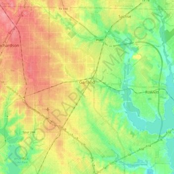
Name: Topografische Karte Garland, Höhe, Relief.

Ort: Garland, Dallas County, Texas, United States (32.83014 -96.70576 32.98559 -96.50552)

Durchschnittliche Höhe: 165 m

Minimale Höhe: 126 m

Maximale Höhe: 213 m

Andere topografische Karten

Klicken Sie auf eine Karte, um ihre Topografie, ihre Höhe und ihr Relief anzuzeigen.

Lake Shirley

United States > Texas > Dallas County > Dallas

Durchschnittliche Höhe: 199 m

Reinhardt

United States > Texas > Dallas County > Dallas

Durchschnittliche Höhe: 164 m

Zacha Junction

United States > Texas > Dallas County > Dallas

Durchschnittliche Höhe: 176 m

Centerville

United States > Texas > Dallas County > Garland

Durchschnittliche Höhe: 159 m

Kessler Parkway

United States > Texas > Dallas County > Dallas

Durchschnittliche Höhe: 137 m

Klyde Warren Park

United States > Texas > Dallas County > Dallas

Durchschnittliche Höhe: 142 m

Gifford

United States > Texas > Dallas County > Dallas

Durchschnittliche Höhe: 170 m

Joppa

United States > Texas > Dallas County > Dallas

Durchschnittliche Höhe: 126 m

Red Bird Addition

United States > Texas > Dallas County > Duncanville

Durchschnittliche Höhe: 221 m

Ledbetter Hills

United States > Texas > Dallas County > Dallas

Durchschnittliche Höhe: 199 m

Dealey Plaza

United States > Texas > Dallas County > Dallas

Durchschnittliche Höhe: 132 m

Dallas

United States > Texas > Dallas County > Dallas

Dallas and its surrounding area are mostly flat. The city lies at elevations ranging from 450 to 550 feet (137 to 168 m) above sea level. The western edge of the Austin Chalk Formation, a limestone escarpment (also known as the "White Rock Escarpment"), rises 230 feet (70 m) and runs roughly north–south…

Durchschnittliche Höhe: 158 m

Reinhardt

United States > Texas > Dallas County > Dallas

Durchschnittliche Höhe: 164 m

Highland

United States > Texas > Dallas County > Dallas

Durchschnittliche Höhe: 133 m

Kenwood

United States > Texas > Dallas County > Dallas

Durchschnittliche Höhe: 199 m

Kleberg

United States > Texas > Dallas County > Dallas

Durchschnittliche Höhe: 129 m

Red Bird Addition

United States > Texas > Dallas County > Duncanville

Durchschnittliche Höhe: 221 m

Bouchard

United States > Texas > Dallas County > Dallas

Durchschnittliche Höhe: 171 m

Tripp

United States > Texas > Dallas County > Sunnyvale

Durchschnittliche Höhe: 143 m

Reinhardt

United States > Texas > Dallas County > Dallas

Durchschnittliche Höhe: 164 m

Gifford

United States > Texas > Dallas County > Dallas

Durchschnittliche Höhe: 170 m

Klyde Warren Park

United States > Texas > Dallas County > Dallas

Durchschnittliche Höhe: 142 m

Grand Prairie

United States > Texas > Dallas County > Grand Prairie

Durchschnittliche Höhe: 170 m

Coppell

United States > Texas > Dallas County > Coppell

Durchschnittliche Höhe: 160 m

Pioneer Park

United States > Texas > Dallas County > Dallas

Durchschnittliche Höhe: 135 m

Irving

United States > Texas > Dallas County > Irving

Durchschnittliche Höhe: 162 m

Seagoville

United States > Texas > Dallas County > Seagoville

Durchschnittliche Höhe: 122 m

Rüste dich für dein nächstes Abenteuer:

🌡️Hand- und Fusswärmer - Sofortige Wärme bei extremen Minustemperaturen
Outdoor-Kaffeebereiter - Genussvoller Kaffee am Gipfel oder im Basislager
🏕️Familien‑Campingausrüstung - Ausrüstung für Camping mit Familie
👣Einlegesohlen für Komfort - Komfortable Einlagen für lange Wandertage
👟Approach‑Schuhe - Vielseitige Schuhe für Zustiege und leichte Kletterpassagen

Als Amazon-Partner verdient diese Seite an qualifizierten Käufen, ohne dass Ihnen zusätzliche Kosten entstehen.