
Topografische Karte Many Glacier
Interaktive Karte
Klicken Sie auf die Karte, um die Höhe anzuzeigen.
Über diese Karte
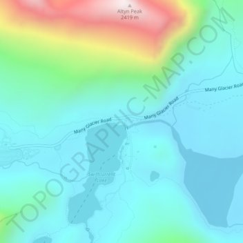
Name: Topografische Karte Many Glacier, Höhe, Relief.
Ort: Many Glacier, Glacier County, Montana, United States (48.79042 -113.66757 48.81042 -113.64757)
Durchschnittliche Höhe: 1’658 m
Minimale Höhe: 1’458 m
Maximale Höhe: 2’416 m
Andere topografische Karten
Klicken Sie auf eine Karte, um ihre Topografie, ihre Höhe und ihr Relief anzuzeigen.
North Browning
United States > Montana > Glacier County
North Browning, Glacier County, Montana, United States
Durchschnittliche Höhe: 1’336 m
South Browning
United States > Montana > Glacier County
South Browning, Glacier County, Montana, United States
Durchschnittliche Höhe: 1’345 m
Calf Robe Mountain
United States > Montana > Glacier County
Calf Robe Mountain, Glacier County, Montana, United States
Durchschnittliche Höhe: 2’020 m
Bullhead Lake
United States > Montana > Glacier County
Bullhead Lake, Glacier County, Montana, United States
Durchschnittliche Höhe: 1’848 m
Chief Mountain
United States > Montana > Glacier County
Chief Mountain, Glacier County, Montana, United States
Durchschnittliche Höhe: 2’196 m
Bison
United States > Montana > Glacier County > Bison
Bison, Glacier County, Montana, United States
Durchschnittliche Höhe: 1’577 m
Durham
United States > Montana > Glacier County > Durham
Durham, Glacier County, Montana, United States
Durchschnittliche Höhe: 1’468 m
Saint Mary
United States > Montana > Glacier County
Saint Mary, Glacier County, Montana, United States
Durchschnittliche Höhe: 1’430 m
Cracker Lake
United States > Montana > Glacier County
Cracker Lake, Glacier County, Montana, United States
Durchschnittliche Höhe: 2’224 m
Mount Cleveland
United States > Montana > Glacier County
Mount Cleveland, Glacier County, Montana, United States
Durchschnittliche Höhe: 2’339 m
Pray Lake
United States > Montana > Glacier County
Pray Lake, Glacier County, Montana, United States
Durchschnittliche Höhe: 1’717 m
Babb
United States > Montana > Glacier County
Babb, Glacier County, Montana, 59411, United States
Durchschnittliche Höhe: 1’432 m
East Flattop Mountain
United States > Montana > Glacier County
East Flattop Mountain, Glacier County, Montana, United States
Durchschnittliche Höhe: 2’241 m
Browning
United States > Montana > Glacier County
Browning, Glacier County, Montana, United States
Durchschnittliche Höhe: 1’338 m
East Glacier Park Village
United States > Montana > Glacier County
East Glacier Park Village, Glacier County, Montana, 59434, United States
Durchschnittliche Höhe: 1’530 m
Cut Bank
United States > Montana > Glacier County
Cut Bank, Glacier County, Montana, United States
Durchschnittliche Höhe: 1’147 m