
Topografische Karte Ein Gedi
Interaktive Karte
Klicken Sie auf die Karte, um die Höhe anzuzeigen.
Über diese Karte
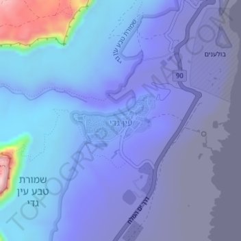
Name: Topografische Karte Ein Gedi, Höhe, Relief.
Durchschnittliche Höhe: -266 m
Minimale Höhe: -415 m
Maximale Höhe: 209 m
Andere topografische Karten
Klicken Sie auf eine Karte, um ihre Topografie, ihre Höhe und ihr Relief anzuzeigen.
Masada
Israel > South District > Tamar Regional Council
Masada, Ramp path, Tamar Regional Council, Beersheba Subdistrict, South District, Israel
Durchschnittliche Höhe: -133 m
Neve Zohar
Israel > South District > Tamar Regional Council
Neve Zohar, Tamar Regional Council, Beersheba Subdistrict, South District, Israel
Durchschnittliche Höhe: -327 m
HaMakhtesh HaKatan
Israel > South District > Tamar Regional Council
HaMakhtesh HaKatan, Malla Hazara, Tamar Regional Council, South District, no, Israel
Durchschnittliche Höhe: 119 m