
Topografische Karte Mae Hong Son
Interaktive Karte
Klicken Sie auf die Karte, um die Höhe anzuzeigen.
Über diese Karte
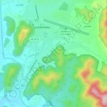
Name: Topografische Karte Mae Hong Son, Höhe, Relief.
Ort: Mae Hong Son, Mae Hong Son Province, 58000, Thailand (19.27171 97.95096 19.31171 97.99096)
Durchschnittliche Höhe: 289 m
Minimale Höhe: 193 m
Maximale Höhe: 555 m
Andere topografische Karten
Klicken Sie auf eine Karte, um ihre Topografie, ihre Höhe und ihr Relief anzuzeigen.
Mae Sariang
Thailand > Mae Hong Son Province
Mae Sariang, Mae Hong Son Province, 58110, Thailand
Durchschnittliche Höhe: 242 m
Pai River
Thailand > Mae Hong Son Province > Ban Thung Kong Mu
Pai River, Ban Thung Kong Mu, Mae Hong Son, Mae Hong Son Province, Thailand
Durchschnittliche Höhe: 319 m
Salawin National Park
Thailand > Mae Hong Son Province
Salawin National Park, Mae Sariang, Mae Hong Son Province, Thailand
Durchschnittliche Höhe: 492 m
Pai
Thailand > Mae Hong Son Province
Pai, Mae Hong Son Province, 58130, Thailand
Durchschnittliche Höhe: 605 m
Tham Lod Cave
Thailand > Mae Hong Son Province
Tham Lod Cave, มส.4014, Mae Hong Son Province, 58150, Thailand
Durchschnittliche Höhe: 748 m
Mae Hong Son
Thailand > Mae Hong Son Province > Mae Hong Son
Mae Hong Son, Mae Hong Son Province, 58000, Thailand
Durchschnittliche Höhe: 592 m