
Topografische Karte Sheep River
Klicken Sie auf die Karte, um die Höhe anzuzeigen.
Über diese Karte
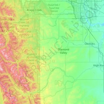
Name: Topografische Karte Sheep River, Höhe, Relief.
Ort: Sheep River, Foothills County, Alberta, Canada (50.59580 -114.95603 50.73978 -113.85476)
Durchschnittliche Höhe: 1’426 m
Minimale Höhe: 960 m
Maximale Höhe: 3’115 m
Andere topografische Karten
Klicken Sie auf eine Karte, um ihre Topografie, ihre Höhe und ihr Relief anzuzeigen.
Highwood River
Canada > Alberta > Foothills County > Village of Longview
Durchschnittliche Höhe: 1’232 m
Priddis
Canada > Alberta > Foothills County
Priddis is a hamlet in Alberta, Canada within Foothills County. It is located in the foothills of the Canadian Rockies at an elevation of 1,160 metres (3,810 ft). The hamlet is located southwest of the intersection of the Cowboy Trail (Highway 22) and Highway 22X, approximately 10 kilometres (6.2 mi) west of…
Durchschnittliche Höhe: 1’193 m