
Topografische Karte Le Grand Carvidy
Interaktive Karte
Klicken Sie auf die Karte, um die Höhe anzuzeigen.
Über diese Karte
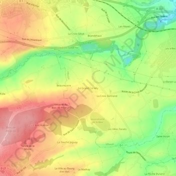
Name: Topografische Karte Le Grand Carvidy, Höhe, Relief.
Durchschnittliche Höhe: 105 m
Minimale Höhe: 26 m
Maximale Höhe: 173 m
Andere topografische Karten
Klicken Sie auf eine Karte, um ihre Topografie, ihre Höhe und ihr Relief anzuzeigen.
La Croix Bertrand
France > Bretagne > Côtes-d'Armor > Yffiniac
La Croix Bertrand, Yffiniac, Saint-Brieuc, Côtes-d'Armor, Bretagne, France métropolitaine, 22120, France
Durchschnittliche Höhe: 99 m
Les Fraîches
France > Bretagne > Côtes-d'Armor > Yffiniac > Les Fraîches
Les Fraîches, Yffiniac, Saint-Brieuc, Côtes-d'Armor, Bretagne, France métropolitaine, 22120, France
Durchschnittliche Höhe: 43 m