
Topografische Karte Welkom
Interaktive Karte
Klicken Sie auf die Karte, um die Höhe anzuzeigen.
Über diese Karte
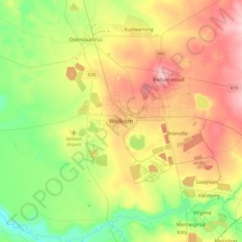
Name: Topografische Karte Welkom, Höhe, Relief.
Durchschnittliche Höhe: 1’341 m
Minimale Höhe: 1’271 m
Maximale Höhe: 1’436 m
Koppie Alleen is the only hill near Welkom and therefore is aptly named for its oddity. The terrain elevation above sea level is 1435 metres. The largest water catchment is the Sand River to the south-east of Welkom in Virginia's direction. Large saline pans such as Flamingo Pan and Theronia Pan are situated to the south-west of Welkom. Flamingo Pan is coded as an Important Bird Area (IBA)
Andere topografische Karten
Klicken Sie auf eine Karte, um ihre Topografie, ihre Höhe und ihr Relief anzuzeigen.
Winnie Mandela
South Africa > Free State > Lejweleputswa District Municipality > Masilonyana Local Municipality
Winnie Mandela, Masilonyana Local Municipality, Lejweleputswa District Municipality, Free State, 9400, South Africa
Durchschnittliche Höhe: 1’403 m
Winburg
South Africa > Free State > Lejweleputswa District Municipality > Masilonyana Local Municipality
Winburg, Masilonyana Local Municipality, Lejweleputswa District Municipality, Free State, South Africa
Durchschnittliche Höhe: 1’449 m
Brandfort
South Africa > Free State > Lejweleputswa District Municipality > Masilonyana Local Municipality > Winnie Mandela
Brandfort, Masilonyana Ward 3, Winnie Mandela, Masilonyana Local Municipality, Lejweleputswa District Municipality, Free State, 9400, South Africa
Durchschnittliche Höhe: 1’402 m
Virginia
South Africa > Free State > Lejweleputswa District Municipality > Matjhabeng Local Municipality > Virginia
Virginia, Matjhabeng Local Municipality, Lejweleputswa District Municipality, Free State, South Africa
Durchschnittliche Höhe: 1’326 m