
Topografische Karte McRoberts
Interaktive Karte
Klicken Sie auf die Karte, um die Höhe anzuzeigen.
Über diese Karte
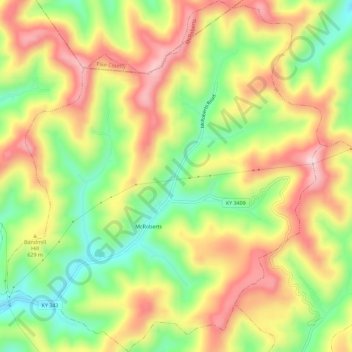
Name: Topografische Karte McRoberts, Höhe, Relief.
Ort: McRoberts, Letcher County, Kentucky, 41835, United States (37.19136 -82.69480 37.23677 -82.64368)
Durchschnittliche Höhe: 572 m
Minimale Höhe: 407 m
Maximale Höhe: 738 m
Andere topografische Karten
Klicken Sie auf eine Karte, um ihre Topografie, ihre Höhe und ihr Relief anzuzeigen.
Jenkins
United States > Kentucky > Letcher County
Jenkins, Letcher County, Kentucky, 41517, United States
Durchschnittliche Höhe: 590 m
Fleming-Neon
United States > Kentucky > Letcher County
Fleming-Neon, Letcher County, Kentucky, United States
Durchschnittliche Höhe: 489 m
Roxana
United States > Kentucky > Letcher County
Roxana, Letcher County, Kentucky, 41832, United States
Durchschnittliche Höhe: 425 m
Gordon
United States > Kentucky > Letcher County
Gordon, Letcher County, Kentucky, 40823, United States
Durchschnittliche Höhe: 587 m
Whitesburg
United States > Kentucky > Letcher County
Whitesburg, Letcher County, Kentucky, United States
Durchschnittliche Höhe: 446 m
Dunham
United States > Kentucky > Letcher County > Jenkins
Dunham, Jenkins, Letcher County, Kentucky, 41835, United States
Durchschnittliche Höhe: 563 m
Neon
United States > Kentucky > Letcher County > Fleming-Neon > Neon
Neon, Fleming-Neon, Letcher County, Kentucky, 41840, United States
Durchschnittliche Höhe: 486 m
Ermine
United States > Kentucky > Letcher County > Ermine
Ermine, Letcher County, Kentucky, 41837, United States
Durchschnittliche Höhe: 447 m
Eolia
United States > Kentucky > Letcher County
Eolia, Letcher County, Kentucky, 40826, United States
Durchschnittliche Höhe: 612 m