
Topografische Karte Pleasanton
Interaktive Karte
Klicken Sie auf die Karte, um die Höhe anzuzeigen.
Über diese Karte
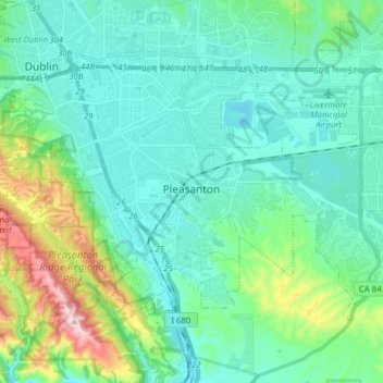
Name: Topografische Karte Pleasanton, Höhe, Relief.
Ort: Pleasanton, Alameda County, California, United States (37.62006 -121.95497 37.70304 -121.79892)
Durchschnittliche Höhe: 187 m
Minimale Höhe: 70 m
Maximale Höhe: 663 m
Andere topografische Karten
Klicken Sie auf eine Karte, um ihre Topografie, ihre Höhe und ihr Relief anzuzeigen.
Oakland
United States > California > Alameda County
Oakland, Alameda County, California, United States
Durchschnittliche Höhe: 51 m
Livermore
United States > California > Alameda County
Livermore, Alameda County, CAL Fire Northern Region, California, 94550, United States
Durchschnittliche Höhe: 184 m
Emeryville
United States > California > Alameda County > Emeryville
Emeryville, Alameda County, California, 94608, United States
Durchschnittliche Höhe: 13 m