
Topografische Karte Whistler Resort Municipality
Interaktive Karte
Klicken Sie auf die Karte, um die Höhe anzuzeigen.
Über diese Karte
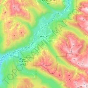
Name: Topografische Karte Whistler Resort Municipality, Höhe, Relief.
Durchschnittliche Höhe: 1’343 m
Minimale Höhe: 499 m
Maximale Höhe: 2’607 m
Reconnu pour être le plus grand domaine skiable en Amérique (élu piste numéro 1 par la revue Ski Magazine), Whistler-Blackcomb aurait, pour certains amateurs de ski, des pentes supérieures à celles de la Suisse, de l'Autriche, de l'Italie ou de la France, en particulier grâce aux quantités impressionnantes de neige qu'il y tombe chaque année. Ce domaine skiable comprend deux montagnes. la Whistler Moutain (altitude. 2182 m) et le Blackcomb Peak (altitude. 2440 m). Le domaine skiable est desservi par un système de 37 remontées mécaniques de dernière technologie (3 télécabines, 19 télésièges, 16 téléskis). Le point culminant du domaine à 2240 m offre un dénivelé de plus de 1500 m pour rejoindre le village. Il est possible de skier en été sur le glacier de Blackcomb.
Andere topografische Karten
Klicken Sie auf eine Karte, um ihre Topografie, ihre Höhe und ihr Relief anzuzeigen.
Whistler Village
Canada > Colombie-Britannique > Squamish-Lillooet Regional District > Whistler Resort Municipality
Whistler Village, Whistler Resort Municipality, Squamish-Lillooet Regional District, Colombie-Britannique, V8E 1H4, Canada
Durchschnittliche Höhe: 775 m
Lillooet River
Canada > Colombie-Britannique > Squamish-Lillooet Regional District > Area C (Pemberton Valley/Mount Currie/D'Arcy)
Lillooet River, Area C (Pemberton Valley/Mount Currie/D'Arcy), Squamish-Lillooet Regional District, Colombie-Britannique, Canada
Durchschnittliche Höhe: 342 m
Squamish
Canada > Colombie-Britannique > Squamish-Lillooet Regional District
Squamish, Squamish-Lillooet Regional District, Colombie-Britannique, Canada
Durchschnittliche Höhe: 844 m
Whistler
Canada > Colombie-Britannique > Squamish-Lillooet Regional District > Whistler Resort Municipality > Whistler
Whistler, Whistler Resort Municipality, Squamish-Lillooet Regional District, Colombie-Britannique, 8E 0X5, Canada
Durchschnittliche Höhe: 996 m