
Topografische Karte Crich CP
Klicken Sie auf die Karte, um die Höhe anzuzeigen.
Crich CP
The memorial tower ('Crich Stand') was completed in 1923 as a memorial to the 11,409 soldiers from the Sherwood Foresters Regiment who died in World War I, a dedication that was later extended to include World War II. It was built on an limestone outcrop above the village, at an altitude of 1,000 feet (300 m) above sea level. The location is symbolic because it is widely visible across, and gives views of, both of the two counties from which the regiment was raised (Nottinghamshire and Derbyshire). It is the destination of an annual pilgrimage on the first Sunday in July.
Über diese Karte
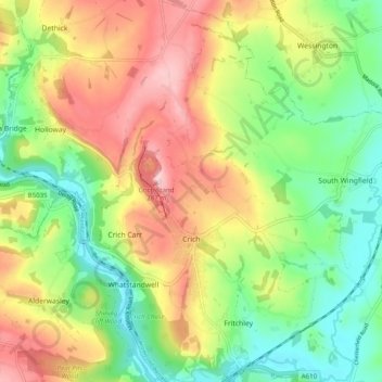
Name: Topografische Karte Crich CP, Höhe, Relief.
Durchschnittliche Höhe: 159 m
Minimale Höhe: 67 m
Maximale Höhe: 278 m
Andere topografische Karten
Klicken Sie auf eine Karte, um ihre Topografie, ihre Höhe und ihr Relief anzuzeigen.
Heanor
United Kingdom > England > Derbyshire > Amber Valley
Samuel Lewis's A Topographical Dictionary of England, published in 1848, states that Heanor parish "abounds with coal and ironstone, both worked extensively, the collieries alone affording employment to more than 2000 persons. The town is pleasantly situated upon an eminence, on the road from Derby to…
Durchschnittliche Höhe: 102 m
Denby Bottles
United Kingdom > England > Derbyshire > Amber Valley > Denby CP
Durchschnittliche Höhe: 108 m
Denby Common
United Kingdom > England > Derbyshire > Amber Valley > Denby CP
Durchschnittliche Höhe: 116 m
Wakebridge
United Kingdom > England > Derbyshire > Amber Valley > Crich CP
Durchschnittliche Höhe: 181 m
Lea Wood
United Kingdom > England > Derbyshire > Amber Valley > Lea Bridge
Durchschnittliche Höhe: 154 m
Rawson Green
United Kingdom > England > Derbyshire > Amber Valley > Kilburn CP
Durchschnittliche Höhe: 109 m
Nottingham Canal
United Kingdom > England > Derbyshire > Amber Valley > Langley Mill
Durchschnittliche Höhe: 77 m
Upper Holloway
United Kingdom > England > Derbyshire > Amber Valley > Holloway
Durchschnittliche Höhe: 189 m
Alfreton Park
United Kingdom > England > Derbyshire > Amber Valley > Alfreton CP > Oakerthorpe
Durchschnittliche Höhe: 116 m
Plaistow Green
United Kingdom > England > Derbyshire > Amber Valley > Crich CP
Durchschnittliche Höhe: 180 m
Sawmills
United Kingdom > England > Derbyshire > Amber Valley > Ripley > Fritchley
Durchschnittliche Höhe: 119 m
Upper Hartshay
United Kingdom > England > Derbyshire > Amber Valley > Upper Hartshay
Durchschnittliche Höhe: 119 m
Leabrooks
United Kingdom > England > Derbyshire > Amber Valley > Leabrooks
Durchschnittliche Höhe: 122 m
Farnah Green
United Kingdom > England > Derbyshire > Amber Valley > Blackbrook > Farnah Green
Durchschnittliche Höhe: 117 m
Pye Bridge
United Kingdom > England > Derbyshire > Amber Valley > Pye Bridge
Durchschnittliche Höhe: 108 m
Moscow Farm
United Kingdom > England > Derbyshire > Amber Valley > Makeney > Moscow Farm
Durchschnittliche Höhe: 103 m
Mugginton
United Kingdom > England > Derbyshire > Amber Valley > Mugginton
Durchschnittliche Höhe: 136 m
Heanor
United Kingdom > England > Derbyshire > Amber Valley
Samuel Lewis's A Topographical Dictionary of England, published in 1848, states that Heanor parish "abounds with coal and ironstone, both worked extensively, the collieries alone affording employment to more than 2000 persons. The town is pleasantly situated upon an eminence, on the road from Derby to…
Durchschnittliche Höhe: 102 m