
Spenden
Rüste dich für dein nächstes Abenteuer:
Als Amazon-Partner verdient diese Seite an qualifizierten Käufen, ohne dass Ihnen zusätzliche Kosten entstehen.
Topografische Karte Sungai Rompin
Klicken Sie auf die Karte, um die Höhe anzuzeigen.
Spenden
Rüste dich für dein nächstes Abenteuer:
Als Amazon-Partner verdient diese Seite an qualifizierten Käufen, ohne dass Ihnen zusätzliche Kosten entstehen.
Über diese Karte
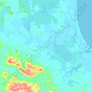
Name: Topografische Karte Sungai Rompin, Höhe, Relief.
Ort: Sungai Rompin, Pahang, Malaysia (2.74657 103.11299 2.90965 103.48313)
Durchschnittliche Höhe: 66 m
Minimale Höhe: -3 m
Maximale Höhe: 820 m
Spenden
Rüste dich für dein nächstes Abenteuer:
Als Amazon-Partner verdient diese Seite an qualifizierten Käufen, ohne dass Ihnen zusätzliche Kosten entstehen.
Andere topografische Karten
Klicken Sie auf eine Karte, um ihre Topografie, ihre Höhe und ihr Relief anzuzeigen.
Pahang
The highest peak, Mount Tahan, reaches 2,187 m (7,175 ft) in elevation, which is also the highest point in the Peninsular Malaysia. The climate is temperate enough to have distinct temperature variations year round, and much of the highlands are covered with tropical rainforest. Pahang is home to Malaysia's…
Durchschnittliche Höhe: 90 m
Spenden
Rüste dich für dein nächstes Abenteuer:
Als Amazon-Partner verdient diese Seite an qualifizierten Käufen, ohne dass Ihnen zusätzliche Kosten entstehen.
Cameron Highlands
Surveyed by the government geologist and explorer William Cameron in 1885, the outpost consists of three mukims (subdistricts), namely Ringlet, Tanah Rata and Ulu Telom. Its eight settlements are Ringlet, Tanah Rata (the administrative centre), Brinchang, the Bertam Valley, Kea Farm, Tringkap, Kampung Kuala…
Durchschnittliche Höhe: 1’400 m
Genting Highlands
Genting Highlands is a hill station and a city located on the peak of Mount Ulu Kali in the Titiwangsa Mountains, central Peninsular Malaysia, at 1800 metres elevation. It is the second seat of Bentong District after Bentong. Located in the state of Pahang. It was established in 1965 by the late Malaysian…
Durchschnittliche Höhe: 1’141 m
Genting Highlands
Genting Highlands is a hill station located on the peak of Mount Ulu Kali in the Titiwangsa Mountains, central Peninsular Malaysia, at 1800 metres elevation. Located in the state of Pahang, it was established in 1965 by the late Malaysian businessman Lim Goh Tong. The primary tourist attraction is Resorts…
Durchschnittliche Höhe: 1’141 m
Spenden
Rüste dich für dein nächstes Abenteuer:
Als Amazon-Partner verdient diese Seite an qualifizierten Käufen, ohne dass Ihnen zusätzliche Kosten entstehen.
Tanah Rata
Tanah Rata is a town located in Cameron Highlands, Pahang, Malaysia. The name "tanah rata" means flat ground in Malay and it refers to the relatively flat area on which the town is located amidst this highland region. It has an elevation of 1,440 metres (4,720 ft).
Durchschnittliche Höhe: 1’393 m
Spenden
Rüste dich für dein nächstes Abenteuer:
Als Amazon-Partner verdient diese Seite an qualifizierten Käufen, ohne dass Ihnen zusätzliche Kosten entstehen.
Tanah Rata
Tanah Rata is a town located in Cameron Highlands, Pahang, Malaysia. The name "tanah rata" means flat ground in Malay and it refers to the relatively flat area on which the town is located amidst this highland region. It has an elevation of 1,440 metres (4,720 ft).
Durchschnittliche Höhe: 1’393 m
Spenden
Rüste dich für dein nächstes Abenteuer:
Als Amazon-Partner verdient diese Seite an qualifizierten Käufen, ohne dass Ihnen zusätzliche Kosten entstehen.
Malaysia National Park
Taman Negara has a total area of 4,343 km2 and it is one of the world's oldest rainforests, estimated to be more than 130 million years old. Mount Tahan, Peninsular Malaysia's highest point with an elevation of 7,175 ft (2,187 m) above sea level, is within the park's boundaries. Taman Negara is an important…
Durchschnittliche Höhe: 316 m
Ringlet
Situated at an altitude of 1,135 metres above sea level (3,723 ft), Ringlet is a hub of Malaysia's vegetable farming and international flower farming sector. The town contains some other small villages such as Bertam Valley, Boh and Habu Height.
Durchschnittliche Höhe: 1’183 m
Spenden
Rüste dich für dein nächstes Abenteuer:
Als Amazon-Partner verdient diese Seite an qualifizierten Käufen, ohne dass Ihnen zusätzliche Kosten entstehen.
Spenden
Rüste dich für dein nächstes Abenteuer:
Als Amazon-Partner verdient diese Seite an qualifizierten Käufen, ohne dass Ihnen zusätzliche Kosten entstehen.
Spenden
Rüste dich für dein nächstes Abenteuer:
Als Amazon-Partner verdient diese Seite an qualifizierten Käufen, ohne dass Ihnen zusätzliche Kosten entstehen.
Cameron Highlands
Surveyed by the government geologist and explorer William Cameron in 1885, the outpost consists of three mukims (subdistricts), namely Ringlet, Tanah Rata and Ulu Telom. Its eight settlements are Ringlet, Tanah Rata (the administrative centre), Brinchang, the Bertam Valley, Kea Farm, Tringkap, Kampung Kuala…
Durchschnittliche Höhe: 1’105 m
Ringlet
Situated at an altitude of 1,135 metres above sea level (3,723 ft), Ringlet is a hub of Malaysia's vegetable farming and international flower farming sector. The town contains some other small villages such as Bertam Valley, Boh and Habu Height.
Durchschnittliche Höhe: 1’183 m
Spenden
Rüste dich für dein nächstes Abenteuer:
Als Amazon-Partner verdient diese Seite an qualifizierten Käufen, ohne dass Ihnen zusätzliche Kosten entstehen.
Cameron Highlands
Surveyed by the government geologist and explorer William Cameron in 1885, the outpost consists of three mukims (subdistricts), namely Ringlet, Tanah Rata and Ulu Telom. Its eight settlements are Ringlet, Tanah Rata (the administrative centre), Brinchang, the Bertam Valley, Kea Farm, Tringkap, Kampung Kuala…
Durchschnittliche Höhe: 1’105 m
Spenden
Rüste dich für dein nächstes Abenteuer:
Als Amazon-Partner verdient diese Seite an qualifizierten Käufen, ohne dass Ihnen zusätzliche Kosten entstehen.
Spenden
Rüste dich für dein nächstes Abenteuer:
Als Amazon-Partner verdient diese Seite an qualifizierten Käufen, ohne dass Ihnen zusätzliche Kosten entstehen.
Spenden
Rüste dich für dein nächstes Abenteuer:
Als Amazon-Partner verdient diese Seite an qualifizierten Käufen, ohne dass Ihnen zusätzliche Kosten entstehen.
Spenden
Rüste dich für dein nächstes Abenteuer:
Als Amazon-Partner verdient diese Seite an qualifizierten Käufen, ohne dass Ihnen zusätzliche Kosten entstehen.
Genting Highlands
Genting Highlands is a hill station located on the peak of Mount Ulu Kali in the Titiwangsa Mountains, central Peninsular Malaysia, at 1800 metres elevation. Located in the state of Pahang, it was established in 1965 by the late Malaysian businessman Lim Goh Tong. The primary tourist attraction is Resorts…
Durchschnittliche Höhe: 1’141 m
Mount Tahan
Mount Tahan (Malay: Gunung Tahan), is the highest point in Peninsular Malaysia with an elevation of 2,187 m (7,175 ft) above sea level, on the border between the states of Pahang and Kelantan, with the peak lying on the Pahangite side. It is part of the Taman Negara that straddles Jerantut District in Pahang,…
Durchschnittliche Höhe: 1’829 m
Spenden
Rüste dich für dein nächstes Abenteuer:
Als Amazon-Partner verdient diese Seite an qualifizierten Käufen, ohne dass Ihnen zusätzliche Kosten entstehen.
Spenden
Rüste dich für dein nächstes Abenteuer:
Als Amazon-Partner verdient diese Seite an qualifizierten Käufen, ohne dass Ihnen zusätzliche Kosten entstehen.
Spenden
Rüste dich für dein nächstes Abenteuer:
Als Amazon-Partner verdient diese Seite an qualifizierten Käufen, ohne dass Ihnen zusätzliche Kosten entstehen.
Malay Peninsula
The Kangar-Pattani floristic boundary crosses the peninsula in southern Thailand and northernmost Malaysia, marking the boundary between the large biogeographic regions of Indochina to the north and Sundaland and Malesia to the south. The forests north of the boundary are characterized by seasonally-deciduous…
Durchschnittliche Höhe: 140 m
Spenden
Rüste dich für dein nächstes Abenteuer:
Als Amazon-Partner verdient diese Seite an qualifizierten Käufen, ohne dass Ihnen zusätzliche Kosten entstehen.
Sungai Ruan
Covering a total area of 9.7 square km at an average elevation of 227 meters above sea level, the village is surrounded by hills, forest and plantations with a population of about 6,000 people.
Durchschnittliche Höhe: 142 m
Cameron Highlands
Surveyed by the government geologist and explorer William Cameron in 1885, the outpost consists of three mukims (subdistricts), namely Ringlet, Tanah Rata and Ulu Telom. Its eight settlements are Ringlet, Tanah Rata (the administrative centre), Brinchang, the Bertam Valley, Kea Farm, Tringkap, Kampung Kuala…
Durchschnittliche Höhe: 1’400 m
Sungei Palas Boh Plantation Viewpoint
Malaysia > Pahang > Cameron Highlands
Durchschnittliche Höhe: 1’536 m
Spenden
Rüste dich für dein nächstes Abenteuer:
Als Amazon-Partner verdient diese Seite an qualifizierten Käufen, ohne dass Ihnen zusätzliche Kosten entstehen.
Brinchang
Brinchang (also spelt Berincang) is a town and hill resort located at an altitude of 1,540 metres (5,050 ft) in Cameron Highlands in the state of Pahang, Malaysia. The town's name is derived from nearby Gunung Brinchang, which is the second highest point in Cameron Highlands.
Durchschnittliche Höhe: 1’524 m
Spenden
Rüste dich für dein nächstes Abenteuer:
Als Amazon-Partner verdient diese Seite an qualifizierten Käufen, ohne dass Ihnen zusätzliche Kosten entstehen.
Spenden
Rüste dich für dein nächstes Abenteuer:
Als Amazon-Partner verdient diese Seite an qualifizierten Käufen, ohne dass Ihnen zusätzliche Kosten entstehen.
Brinchang
Brinchang (also spelt Berincang) is a town and hill resort located at an altitude of 1,540 metres (5,050 ft) in Cameron Highlands in the state of Pahang, Malaysia. The town's name is derived from nearby Gunung Brinchang, which is the second highest point in Cameron Highlands.
Durchschnittliche Höhe: 1’524 m
Spenden
Rüste dich für dein nächstes Abenteuer:
Als Amazon-Partner verdient diese Seite an qualifizierten Käufen, ohne dass Ihnen zusätzliche Kosten entstehen.
Kampung Janda Baik
Before Janda Baik was founded in 1930, the area was primarily inhabited by Orang Asli tribes. The village was founded when some residents moved from Bentong to an area with a higher elevation due to the 1926 floods that affected Bentong and other low elevation areas. The earliest founders for this village are…
Durchschnittliche Höhe: 467 m
Genting Highlands
Genting Highlands is a hill station located on the peak of Mount Ulu Kali in the Titiwangsa Mountains, central Peninsular Malaysia, at 1800 metres elevation. Located in the state of Pahang, it was established in 1965 by the late Malaysian businessman Lim Goh Tong. The primary tourist attraction is Resorts…
Durchschnittliche Höhe: 1’517 m
Spenden
Rüste dich für dein nächstes Abenteuer:
Als Amazon-Partner verdient diese Seite an qualifizierten Käufen, ohne dass Ihnen zusätzliche Kosten entstehen.
Spenden
Rüste dich für dein nächstes Abenteuer:
Als Amazon-Partner verdient diese Seite an qualifizierten Käufen, ohne dass Ihnen zusätzliche Kosten entstehen.
Spenden
Rüste dich für dein nächstes Abenteuer:
Als Amazon-Partner verdient diese Seite an qualifizierten Käufen, ohne dass Ihnen zusätzliche Kosten entstehen.
Spenden
Rüste dich für dein nächstes Abenteuer:
Als Amazon-Partner verdient diese Seite an qualifizierten Käufen, ohne dass Ihnen zusätzliche Kosten entstehen.
Malay Peninsula
The Kangar-Pattani floristic boundary crosses the peninsula in southern Thailand and northernmost Malaysia, marking the boundary between the large biogeographic regions of Indochina to the north and Sundaland and Malesia to the south. The forests north of the boundary are characterized by seasonally-deciduous…
Durchschnittliche Höhe: 140 m
Genting Highlands
Genting Highlands is a hill station located on the peak of Mount Ulu Kali in the Titiwangsa Mountains, central Peninsular Malaysia, at 1800 metres elevation. Located in the state of Pahang, it was established in 1965 by the late Malaysian businessman Lim Goh Tong. The primary tourist attraction is Resorts…
Durchschnittliche Höhe: 1’141 m
Spenden
Rüste dich für dein nächstes Abenteuer:
Als Amazon-Partner verdient diese Seite an qualifizierten Käufen, ohne dass Ihnen zusätzliche Kosten entstehen.