
Spenden
Rüste dich für dein nächstes Abenteuer:
Als Amazon-Partner verdient diese Seite an qualifizierten Käufen, ohne dass Ihnen zusätzliche Kosten entstehen.
Topografische Karte Portola
Klicken Sie auf die Karte, um die Höhe anzuzeigen.
Spenden
Rüste dich für dein nächstes Abenteuer:
Als Amazon-Partner verdient diese Seite an qualifizierten Käufen, ohne dass Ihnen zusätzliche Kosten entstehen.
Über diese Karte
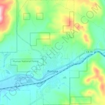
Name: Topografische Karte Portola, Höhe, Relief.
Ort: Portola, Plumas County, California, 96122, United States (39.79166 -120.49562 39.84994 -120.45297)
Durchschnittliche Höhe: 1’570 m
Minimale Höhe: 1’467 m
Maximale Höhe: 1’863 m
Spenden
Rüste dich für dein nächstes Abenteuer:
Als Amazon-Partner verdient diese Seite an qualifizierten Käufen, ohne dass Ihnen zusätzliche Kosten entstehen.
Andere topografische Karten
Klicken Sie auf eine Karte, um ihre Topografie, ihre Höhe und ihr Relief anzuzeigen.
Quincy
United States > California > Plumas County > Quincy
Quincy has a Mediterranean climate (Köppen Csb) though its inland location and altitude makes it more continental and wetter than usual for this type, with very heavy snowfalls sometimes occurring in winter – the record being 133 inches (337.8 cm) in the very wet January 1916. Although summer days are hot…
Durchschnittliche Höhe: 1’274 m
Spenden
Rüste dich für dein nächstes Abenteuer:
Als Amazon-Partner verdient diese Seite an qualifizierten Käufen, ohne dass Ihnen zusätzliche Kosten entstehen.
Little Grass Valley
United States > California > Plumas County > La Porte
About 2.5 miles (4.0 km) north of Little Grass Valley Lake lies a small, natural lily pond called Fowler Lake. Its coordinates are 39°46′27″N 121°00′19″W / 39.77417°N 121.00528°W / 39.77417; -121.00528 (Fowler Lake), and its altitude is 5,446 feet (1,660 m).
Durchschnittliche Höhe: 1’644 m
Spenden
Rüste dich für dein nächstes Abenteuer:
Als Amazon-Partner verdient diese Seite an qualifizierten Käufen, ohne dass Ihnen zusätzliche Kosten entstehen.
Spenden
Rüste dich für dein nächstes Abenteuer:
Als Amazon-Partner verdient diese Seite an qualifizierten Käufen, ohne dass Ihnen zusätzliche Kosten entstehen.
Quincy
United States > California > Plumas County
Quincy has a Mediterranean climate (Köppen Csb) though its inland location and altitude makes it more continental and wetter than usual for this type, with very heavy snowfalls sometimes occurring in winter – the record being 133 inches (337.8 cm) in the very wet January 1916. Although summer days are hot…
Durchschnittliche Höhe: 1’274 m
Spenden
Rüste dich für dein nächstes Abenteuer:
Als Amazon-Partner verdient diese Seite an qualifizierten Käufen, ohne dass Ihnen zusätzliche Kosten entstehen.