
Topografische Karte Fort Loramie
Interaktive Karte
Klicken Sie auf die Karte, um die Höhe anzuzeigen.
Über diese Karte
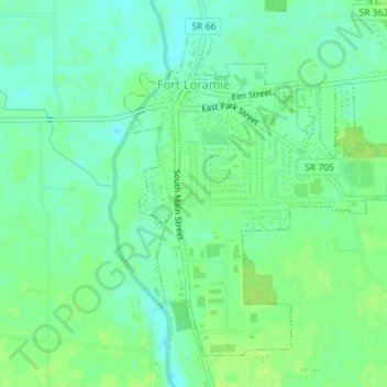
Name: Topografische Karte Fort Loramie, Höhe, Relief.
Ort: Fort Loramie, Shelby County, Ohio, United States (40.33251 -84.38015 40.35516 -84.35594)
Durchschnittliche Höhe: 292 m
Minimale Höhe: 285 m
Maximale Höhe: 298 m
According to the United States Census Bureau, the village has a total area of 0.96 square miles (2.49 km2), all land. The village is at an elevation of 953 feet (290 m) above sea level.
Andere topografische Karten
Klicken Sie auf eine Karte, um ihre Topografie, ihre Höhe und ihr Relief anzuzeigen.
Lockington
United States > Ohio > Shelby County
Lockington, Shelby County, Ohio, United States
Durchschnittliche Höhe: 283 m
Plattsville
United States > Ohio > Shelby County
Plattsville, Shelby County, Ohio, United States
Durchschnittliche Höhe: 332 m
Ballou
United States > Ohio > Shelby County
Ballou, Shelby County, Ohio, 45317, United States
Durchschnittliche Höhe: 338 m
Sidney
United States > Ohio > Shelby County
Sidney, Shelby County, Ohio, 45365, United States
Durchschnittliche Höhe: 312 m
Sidney
United States > Ohio > Shelby County > Sidney > Sidney
Sidney, Shelby County, Ohio, 45365, United States
Durchschnittliche Höhe: 312 m
Russia
United States > Ohio > Shelby County
Russia, Shelby County, Ohio, United States
Durchschnittliche Höhe: 298 m
Jackson Center
United States > Ohio > Shelby County
Jackson Center, Shelby County, Ohio, United States
Durchschnittliche Höhe: 314 m