
Spenden
Rüste dich für dein nächstes Abenteuer:
Als Amazon-Partner verdient diese Seite an qualifizierten Käufen, ohne dass Ihnen zusätzliche Kosten entstehen.
Topografische Karte Arlington
Klicken Sie auf die Karte, um die Höhe anzuzeigen.
Spenden
Rüste dich für dein nächstes Abenteuer:
Als Amazon-Partner verdient diese Seite an qualifizierten Käufen, ohne dass Ihnen zusätzliche Kosten entstehen.
Arlington
The city lies on a glacial terrace formed during the Pleistocene epoch by the recession of the Cordilleran Ice Sheet. Arlington covers a series of hills that sit at an elevation of 100 to 200 feet (30 to 61 m) above sea level. Downtown Arlington is situated on a bluff above the confluence of the Stillaguamish River and its North and South Forks. Most of Arlington sits in the watersheds of the Stillaguamish River, Portage Creek, and Quilceda Creek. From various points in Arlington, the Olympic Mountains, Mount Pilchuck, and Mount Rainier are visible on the horizon.
Spenden
Rüste dich für dein nächstes Abenteuer:
Als Amazon-Partner verdient diese Seite an qualifizierten Käufen, ohne dass Ihnen zusätzliche Kosten entstehen.
Über diese Karte
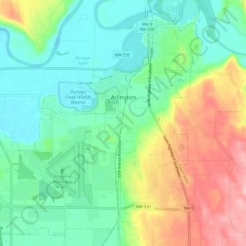
Name: Topografische Karte Arlington, Höhe, Relief.
Durchschnittliche Höhe: 60 m
Minimale Höhe: 6 m
Maximale Höhe: 172 m
Spenden
Rüste dich für dein nächstes Abenteuer:
Als Amazon-Partner verdient diese Seite an qualifizierten Käufen, ohne dass Ihnen zusätzliche Kosten entstehen.
Andere topografische Karten
Klicken Sie auf eine Karte, um ihre Topografie, ihre Höhe und ihr Relief anzuzeigen.
Northwest Snohomish
United States > Washington > Snohomish County > Snohomish
Durchschnittliche Höhe: 52 m
Spenden
Rüste dich für dein nächstes Abenteuer:
Als Amazon-Partner verdient diese Seite an qualifizierten Käufen, ohne dass Ihnen zusätzliche Kosten entstehen.
Glacier Peak
United States > Washington > Snohomish County
Despite its elevation of 10,541 feet (3,213 m), Glacier Peak is a small stratovolcano. Its relatively high summit is a consequence of its location atop a high ridge, but its volcanic portion extends only 1,600–3,200 feet (500–1,000 m) above the underlying ridge. Another Cascade Arc volcano with similar…
Durchschnittliche Höhe: 2’656 m
Spenden
Rüste dich für dein nächstes Abenteuer:
Als Amazon-Partner verdient diese Seite an qualifizierten Käufen, ohne dass Ihnen zusätzliche Kosten entstehen.
Bridal Veil Falls-Lower East Cascade
United States > Washington > Snohomish County
Durchschnittliche Höhe: 621 m
Spenden
Rüste dich für dein nächstes Abenteuer:
Als Amazon-Partner verdient diese Seite an qualifizierten Käufen, ohne dass Ihnen zusätzliche Kosten entstehen.
Whitehorse Mountain
United States > Washington > Snohomish County
Whitehorse Mountain is a peak near the western edge of the North Cascades in Washington state. It is located just southwest of the Sauk River Valley town of Darrington, near the northern boundary of Boulder River Wilderness in Mount Baker-Snoqualmie National Forest. While not of particularly high absolute…
Durchschnittliche Höhe: 1’430 m
Lynnwood
United States > Washington > Snohomish County > Lynnwood > Lynnwood
Durchschnittliche Höhe: 112 m
Spenden
Rüste dich für dein nächstes Abenteuer:
Als Amazon-Partner verdient diese Seite an qualifizierten Käufen, ohne dass Ihnen zusätzliche Kosten entstehen.
Mill Creek
United States > Washington > Snohomish County > Mill Creek > Mill Creek
Durchschnittliche Höhe: 129 m
Spenden
Rüste dich für dein nächstes Abenteuer:
Als Amazon-Partner verdient diese Seite an qualifizierten Käufen, ohne dass Ihnen zusätzliche Kosten entstehen.