
Topografische Karte William B. Bankhead National Forest
Interaktive Karte
Klicken Sie auf die Karte, um die Höhe anzuzeigen.
Über diese Karte
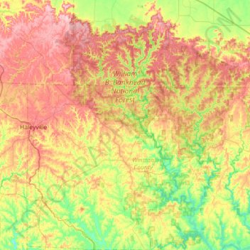
Name: Topografische Karte William B. Bankhead National Forest, Höhe, Relief.
Durchschnittliche Höhe: 232 m
Minimale Höhe: 145 m
Maximale Höhe: 345 m
Andere topografische Karten
Klicken Sie auf eine Karte, um ihre Topografie, ihre Höhe und ihr Relief anzuzeigen.
Lewis Smith Lake
United States > Alabama > Winston County
Lewis Smith Lake, Winston County, Alabama, United States
Durchschnittliche Höhe: 208 m
Haleyville
United States > Alabama > Winston County
Haleyville, Winston County, Alabama, 35565, United States
Durchschnittliche Höhe: 261 m
Wilson Bend
United States > Alabama > Winston County > Wilson Bend
Wilson Bend, Winston County, Alabama, United States
Durchschnittliche Höhe: 175 m
Arley
United States > Alabama > Winston County
Arley, Winston County, Alabama, United States
Durchschnittliche Höhe: 209 m
Double Springs
United States > Alabama > Winston County
Double Springs, Winston County, Alabama, 35553, United States
Durchschnittliche Höhe: 226 m
Natural Bridge
United States > Alabama > Winston County
Natural Bridge, Winston County, Alabama, 35577, United States
Durchschnittliche Höhe: 219 m