
Topografische Karte Whakatikei River
Interaktive Karte
Klicken Sie auf die Karte, um die Höhe anzuzeigen.
Über diese Karte
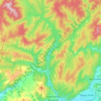
Name: Topografische Karte Whakatikei River, Höhe, Relief.
Durchschnittliche Höhe: 316 m
Minimale Höhe: 52 m
Maximale Höhe: 700 m
Andere topografische Karten
Klicken Sie auf eine Karte, um ihre Topografie, ihre Höhe und ihr Relief anzuzeigen.
Mangaroa River
New Zealand > Wellington > Upper Hutt
Mangaroa River, Upper Hutt, Upper Hutt City, Wellington, 5371, New Zealand
Durchschnittliche Höhe: 283 m
Te Haukaretu Park
New Zealand > Wellington > Upper Hutt
Te Haukaretu Park, Maoribank, Upper Hutt, Upper Hutt City, Wellington, New Zealand
Durchschnittliche Höhe: 113 m
Climie
New Zealand > Wellington > Upper Hutt
Climie, Upper Hutt, Upper Hutt City, Wellington, 5371, New Zealand
Durchschnittliche Höhe: 609 m
Okupe Lagoon
New Zealand > Wellington > Upper Hutt
Okupe Lagoon, Boulder Bank Loop, Upper Hutt, Wellington, New Zealand
Durchschnittliche Höhe: 26 m
Akatarawa River
New Zealand > Wellington > Upper Hutt
Akatarawa River, Upper Hutt, Upper Hutt City, Wellington, 6007, New Zealand
Durchschnittliche Höhe: 428 m