
Spenden
Rüste dich für dein nächstes Abenteuer:
Als Amazon-Partner verdient diese Seite an qualifizierten Käufen, ohne dass Ihnen zusätzliche Kosten entstehen.
Topografische Karte Eure-et-Loir
Klicken Sie auf die Karte, um die Höhe anzuzeigen.
Spenden
Rüste dich für dein nächstes Abenteuer:
Als Amazon-Partner verdient diese Seite an qualifizierten Käufen, ohne dass Ihnen zusätzliche Kosten entstehen.
Über diese Karte
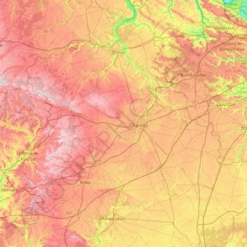
Name: Topografische Karte Eure-et-Loir, Höhe, Relief.
Ort: Eure-et-Loir, Centre-Val de Loire, France métropolitaine, France (47.95402 0.75565 48.94103 1.99454)
Durchschnittliche Höhe: 159 m
Minimale Höhe: 20 m
Maximale Höhe: 298 m
Spenden
Rüste dich für dein nächstes Abenteuer:
Als Amazon-Partner verdient diese Seite an qualifizierten Käufen, ohne dass Ihnen zusätzliche Kosten entstehen.
Andere topografische Karten
Klicken Sie auf eine Karte, um ihre Topografie, ihre Höhe und ihr Relief anzuzeigen.
Parc du Lac des Bretonnières
France > Centre-Val de Loire > Indre-et-Loire > Joué-lès-Tours > La Petite Carte
Durchschnittliche Höhe: 85 m
La Ville
France > Centre-Val de Loire > Indre-et-Loire > Chinon > La Ville
Durchschnittliche Höhe: 52 m
Spenden
Rüste dich für dein nächstes Abenteuer:
Als Amazon-Partner verdient diese Seite an qualifizierten Käufen, ohne dass Ihnen zusätzliche Kosten entstehen.
Les Coutures
France > Centre-Val de Loire > Indre-et-Loire > La Ville-aux-Dames
Durchschnittliche Höhe: 57 m
Spenden
Rüste dich für dein nächstes Abenteuer:
Als Amazon-Partner verdient diese Seite an qualifizierten Käufen, ohne dass Ihnen zusätzliche Kosten entstehen.
Nouy
France > Centre-Val de Loire > Indre-et-Loire > Saint-Martin-le-Beau
Durchschnittliche Höhe: 72 m
Nozieux
France > Centre-Val de Loire > Loir-et-Cher > Saint-Claude-de-Diray
Durchschnittliche Höhe: 82 m
Centre géodésique du cercle minimum de la France continentale
France > Centre-Val de Loire > Indre > Sarzay > Les Sadets
Durchschnittliche Höhe: 215 m
Spenden
Rüste dich für dein nächstes Abenteuer:
Als Amazon-Partner verdient diese Seite an qualifizierten Käufen, ohne dass Ihnen zusätzliche Kosten entstehen.
L'Indre
France > Centre-Val de Loire > Indre > Saint-Genou
Il prend sa source dans le département du Cher, à 454 m d'altitude, au lieu-dit « Beddes », sur le territoire de la commune de Saint-Priest-la-Marche, puis s'écoule vers le nord-ouest.
Durchschnittliche Höhe: 108 m
Spenden
Rüste dich für dein nächstes Abenteuer:
Als Amazon-Partner verdient diese Seite an qualifizierten Käufen, ohne dass Ihnen zusätzliche Kosten entstehen.
La Proutière
France > Centre-Val de Loire > Indre-et-Loire > Épeigné-sur-Dême
Durchschnittliche Höhe: 106 m
Spenden
Rüste dich für dein nächstes Abenteuer:
Als Amazon-Partner verdient diese Seite an qualifizierten Käufen, ohne dass Ihnen zusätzliche Kosten entstehen.
Le Petit Clos du Chêne Maillard
France > Centre-Val de Loire > Loiret > Saran
Durchschnittliche Höhe: 124 m
Château de Chambord
France > Centre-Val de Loire > Loir-et-Cher > Chambord > Le Bourg
Durchschnittliche Höhe: 86 m
Spenden
Rüste dich für dein nächstes Abenteuer:
Als Amazon-Partner verdient diese Seite an qualifizierten Käufen, ohne dass Ihnen zusätzliche Kosten entstehen.
Abbaye de Cornilly
France > Centre-Val de Loire > Loir-et-Cher > Le Controis-en-Sologne
Durchschnittliche Höhe: 111 m
Réserve naturelle des vallées de la Grand-Pierre et de Vitain
France > Centre-Val de Loire > Loir-et-Cher > Averdon > Villiers
Durchschnittliche Höhe: 106 m
Spenden
Rüste dich für dein nächstes Abenteuer:
Als Amazon-Partner verdient diese Seite an qualifizierten Käufen, ohne dass Ihnen zusätzliche Kosten entstehen.
La Plage
France > Centre-Val de Loire > Loir-et-Cher > Faverolles-sur-Cher
Durchschnittliche Höhe: 93 m
Le Bourg-Nord
France > Centre-Val de Loire > Loir-et-Cher > Châtillon-sur-Cher
Durchschnittliche Höhe: 91 m
Spenden
Rüste dich für dein nächstes Abenteuer:
Als Amazon-Partner verdient diese Seite an qualifizierten Käufen, ohne dass Ihnen zusätzliche Kosten entstehen.
La Grande Rue
France > Centre-Val de Loire > Indre-et-Loire > Rochecorbon
Durchschnittliche Höhe: 77 m
Spenden
Rüste dich für dein nächstes Abenteuer:
Als Amazon-Partner verdient diese Seite an qualifizierten Käufen, ohne dass Ihnen zusätzliche Kosten entstehen.
Spenden
Rüste dich für dein nächstes Abenteuer:
Als Amazon-Partner verdient diese Seite an qualifizierten Käufen, ohne dass Ihnen zusätzliche Kosten entstehen.
La CHapelle
France > Centre-Val de Loire > Loir-et-Cher > Chaumont-sur-Loire
Durchschnittliche Höhe: 86 m
La République
France > Centre-Val de Loire > Loir-et-Cher > Montrieux-en-Sologne
Durchschnittliche Höhe: 101 m
Île de Muides
France > Centre-Val de Loire > Loir-et-Cher > Muides-sur-Loire
Durchschnittliche Höhe: 84 m
Spenden
Rüste dich für dein nächstes Abenteuer:
Als Amazon-Partner verdient diese Seite an qualifizierten Käufen, ohne dass Ihnen zusätzliche Kosten entstehen.
Les Trois Cheminées
France > Centre-Val de Loire > Loiret > Lailly-en-Val
Durchschnittliche Höhe: 89 m
Spenden
Rüste dich für dein nächstes Abenteuer:
Als Amazon-Partner verdient diese Seite an qualifizierten Käufen, ohne dass Ihnen zusätzliche Kosten entstehen.
Les Pontonnières
France > Centre-Val de Loire > Loir-et-Cher > Valencisse
Durchschnittliche Höhe: 117 m
Beaulieu
France > Centre-Val de Loire > Eure-et-Loir > Donnemain-Saint-Mamès
Durchschnittliche Höhe: 127 m
Les Malvoisies
France > Centre-Val de Loire > Loir-et-Cher > Fontaine-les-Coteaux
Durchschnittliche Höhe: 129 m
Le Bouillon
France > Centre-Val de Loire > Loir-et-Cher > Saint-Hilaire-la-Gravelle
Durchschnittliche Höhe: 125 m
Spenden
Rüste dich für dein nächstes Abenteuer:
Als Amazon-Partner verdient diese Seite an qualifizierten Käufen, ohne dass Ihnen zusätzliche Kosten entstehen.
Les Dandillons
France > Centre-Val de Loire > Indre-et-Loire > Azay-le-Rideau
Durchschnittliche Höhe: 77 m
Spenden
Rüste dich für dein nächstes Abenteuer:
Als Amazon-Partner verdient diese Seite an qualifizierten Käufen, ohne dass Ihnen zusätzliche Kosten entstehen.
Chausseloup
France > Centre-Val de Loire > Indre-et-Loire > Chanceaux-sur-Choisille
Durchschnittliche Höhe: 96 m
La Terre de la Ceuille Roulée
France > Centre-Val de Loire > Indre-et-Loire > Langeais
Durchschnittliche Höhe: 89 m
Spenden
Rüste dich für dein nächstes Abenteuer:
Als Amazon-Partner verdient diese Seite an qualifizierten Käufen, ohne dass Ihnen zusätzliche Kosten entstehen.
Spenden
Rüste dich für dein nächstes Abenteuer:
Als Amazon-Partner verdient diese Seite an qualifizierten Käufen, ohne dass Ihnen zusätzliche Kosten entstehen.
La Foire de Saint-Roch
France > Centre-Val de Loire > Indre-et-Loire > Saint-Roch
Durchschnittliche Höhe: 96 m
Coteau des Verrons
France > Centre-Val de Loire > Indre-et-Loire > Noizay
Durchschnittliche Höhe: 74 m
Spenden
Rüste dich für dein nächstes Abenteuer:
Als Amazon-Partner verdient diese Seite an qualifizierten Käufen, ohne dass Ihnen zusätzliche Kosten entstehen.
Saint-Sulpice
France > Centre-Val de Loire > Indre-et-Loire > Chambourg-sur-Indre
Durchschnittliche Höhe: 90 m
Petit Beaumont
France > Centre-Val de Loire > Loir-et-Cher > Cour-Cheverny
Durchschnittliche Höhe: 88 m
Spenden
Rüste dich für dein nächstes Abenteuer:
Als Amazon-Partner verdient diese Seite an qualifizierten Käufen, ohne dass Ihnen zusätzliche Kosten entstehen.
Clos des Petits Chaumonniers
France > Centre-Val de Loire > Loiret > Olivet
Durchschnittliche Höhe: 101 m
Spenden
Rüste dich für dein nächstes Abenteuer:
Als Amazon-Partner verdient diese Seite an qualifizierten Käufen, ohne dass Ihnen zusätzliche Kosten entstehen.
Spenden
Rüste dich für dein nächstes Abenteuer:
Als Amazon-Partner verdient diese Seite an qualifizierten Käufen, ohne dass Ihnen zusätzliche Kosten entstehen.
La Croix Lotteau
France > Centre-Val de Loire > Loiret > Châtillon-Coligny
Durchschnittliche Höhe: 140 m
La petite Grange
France > Centre-Val de Loire > Loiret > Saint-Pryvé-Saint-Mesmin
Durchschnittliche Höhe: 97 m
Bourg de Lassay
France > Centre-Val de Loire > Loir-et-Cher > Lassay-sur-Croisne
Durchschnittliche Höhe: 100 m
Spenden
Rüste dich für dein nächstes Abenteuer:
Als Amazon-Partner verdient diese Seite an qualifizierten Käufen, ohne dass Ihnen zusätzliche Kosten entstehen.
Prés de Saint-Gervais
France > Centre-Val de Loire > Loir-et-Cher > Les Roches-l'Évêque
Durchschnittliche Höhe: 100 m
Le Cornet
France > Centre-Val de Loire > Eure-et-Loir > Saint-Lubin-de-la-Haye
Durchschnittliche Höhe: 126 m
Spenden
Rüste dich für dein nächstes Abenteuer:
Als Amazon-Partner verdient diese Seite an qualifizierten Käufen, ohne dass Ihnen zusätzliche Kosten entstehen.
Spenden
Rüste dich für dein nächstes Abenteuer:
Als Amazon-Partner verdient diese Seite an qualifizierten Käufen, ohne dass Ihnen zusätzliche Kosten entstehen.
Le Buisson
France > Centre-Val de Loire > Indre-et-Loire > Tauxigny-Saint-Bauld
Durchschnittliche Höhe: 97 m
Le Stade
France > Centre-Val de Loire > Indre-et-Loire > Montlouis-sur-Loire
Durchschnittliche Höhe: 59 m
Le Papillon
France > Centre-Val de Loire > Indre-et-Loire > Parçay-Meslay
Durchschnittliche Höhe: 103 m
Spenden
Rüste dich für dein nächstes Abenteuer:
Als Amazon-Partner verdient diese Seite an qualifizierten Käufen, ohne dass Ihnen zusätzliche Kosten entstehen.
La Fosse
France > Centre-Val de Loire > Loir-et-Cher > Saint-Martin-des-Bois
Durchschnittliche Höhe: 138 m
Spenden
Rüste dich für dein nächstes Abenteuer:
Als Amazon-Partner verdient diese Seite an qualifizierten Käufen, ohne dass Ihnen zusätzliche Kosten entstehen.