
Topografische Karte Runcadic - Runggaditsch - Roncadizza
Interaktive Karte
Klicken Sie auf die Karte, um die Höhe anzuzeigen.
Über diese Karte
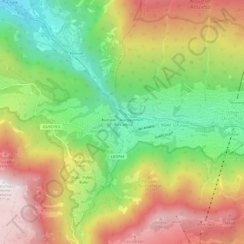
Name: Topografische Karte Runcadic - Runggaditsch - Roncadizza, Höhe, Relief.
Durchschnittliche Höhe: 1’520 m
Minimale Höhe: 952 m
Maximale Höhe: 2’167 m
Andere topografische Karten
Klicken Sie auf eine Karte, um ihre Topografie, ihre Höhe und ihr Relief anzuzeigen.
Seis am Schlern - Siusi allo Sciliar
Italy > Trentino-Alto Adige/Südtirol > South Tyrol > Kastelruth - Castelrotto
Seis am Schlern - Siusi allo Sciliar, Kastelruth - Castelrotto, Salten-Schlern - Salto-Sciliar, South Tyrol, Trentino-Alto Adige/Südtirol, Italy
Durchschnittliche Höhe: 1’211 m
Tiosels
Italy > Trentino-Alto Adige/Südtirol > South Tyrol > Kastelruth - Castelrotto > Kastelruth - Ciastel - Castelrotto > Tiosels
Tiosels, Kastelruth - Ciastel - Castelrotto, Kastelruth - Castelrotto, Salten-Schlern - Salto-Sciliar, South Tyrol, Trentino-Alto Adige/Südtirol, Italy
Durchschnittliche Höhe: 1’275 m
Kastelruth - Ciastel - Castelrotto
Italy > Trentino-Alto Adige/Südtirol > South Tyrol > Kastelruth - Castelrotto > Kastelruth - Ciastel - Castelrotto
Kastelruth - Ciastel - Castelrotto, Kastelruth - Castelrotto, Salten-Schlern - Salto-Sciliar, South Tyrol, Trentino-Alto Adige/Südtirol, Italy
Durchschnittliche Höhe: 1’118 m
Compatsch
Italy > Trentino-Alto Adige/Südtirol > South Tyrol > Kastelruth - Castelrotto
Compatsch, Kastelruth - Castelrotto, Salten-Schlern - Salto-Sciliar, South Tyrol, Trentino-Alto Adige/Südtirol, Italy
Durchschnittliche Höhe: 1’859 m