
Topografische Karte Durango
Interaktive Karte
Klicken Sie auf die Karte, um die Höhe anzuzeigen.
Über diese Karte
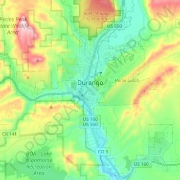
Name: Topografische Karte Durango, Höhe, Relief.
Ort: Durango, La Plata County, Colorado, United States (37.21797 -107.93729 37.32670 -107.82704)
Durchschnittliche Höhe: 2’162 m
Minimale Höhe: 1’939 m
Maximale Höhe: 2’638 m
Durango is located at 37°16′N 107°52′W / 37.267°N 107.867°W / 37.267; -107.867 at an elevation of 6,512 ft (1,988 m). At the 2020 United States Census, the town had a total area of 10,946 acres (44.296 km2) including 1,533 acres (6.203 km2) of water.