
Topografische Karte Grand River
Interaktive Karte
Klicken Sie auf die Karte, um die Höhe anzuzeigen.
Über diese Karte
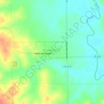
Name: Topografische Karte Grand River, Höhe, Relief.
Ort: Grand River, Decatur County, Iowa, United States (40.81612 -93.96887 40.82142 -93.95739)
Durchschnittliche Höhe: 313 m
Minimale Höhe: 292 m
Maximale Höhe: 351 m
Andere topografische Karten
Klicken Sie auf eine Karte, um ihre Topografie, ihre Höhe und ihr Relief anzuzeigen.
Decatur City
United States > Iowa > Decatur County
Decatur City, Decatur County, Iowa, 50067, United States
Durchschnittliche Höhe: 334 m
Van Wert
United States > Iowa > Decatur County
Van Wert, Decatur County, Iowa, United States
Durchschnittliche Höhe: 346 m
Pleasanton
United States > Iowa > Decatur County
Pleasanton, Decatur County, Iowa, United States
Durchschnittliche Höhe: 320 m
Davis City
United States > Iowa > Decatur County
Davis City, Decatur County, Iowa, 50065, United States
Durchschnittliche Höhe: 281 m
Leon
United States > Iowa > Decatur County
Leon, Decatur County, Iowa, 50144, United States
Durchschnittliche Höhe: 331 m
Garden Grove
United States > Iowa > Decatur County
Garden Grove, Decatur County, Iowa, United States
Durchschnittliche Höhe: 329 m
Weldon
United States > Iowa > Decatur County
Weldon, Decatur County, Iowa, United States
Durchschnittliche Höhe: 346 m
Lamoni
United States > Iowa > Decatur County
Lamoni, Decatur County, Iowa, 50140, United States
Durchschnittliche Höhe: 341 m
Le Roy
United States > Iowa > Decatur County
Le Roy, Decatur County, Iowa, United States
Durchschnittliche Höhe: 337 m