
Topografische Karte West Yellowstone
Interaktive Karte
Klicken Sie auf die Karte, um die Höhe anzuzeigen.
Über diese Karte
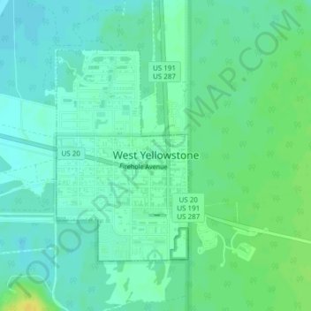
Name: Topografische Karte West Yellowstone, Höhe, Relief.
Ort: West Yellowstone, Gallatin County, Montana, United States (44.65402 -111.11331 44.67239 -111.09720)
Durchschnittliche Höhe: 2’034 m
Minimale Höhe: 2’027 m
Maximale Höhe: 2’048 m
Andere topografische Karten
Klicken Sie auf eine Karte, um ihre Topografie, ihre Höhe und ihr Relief anzuzeigen.
Logan
United States > Montana > Gallatin County
Logan, Gallatin County, Montana, United States
Durchschnittliche Höhe: 1’294 m
Bozeman
United States > Montana > Gallatin County
Bozeman, Gallatin County, Montana, United States
Durchschnittliche Höhe: 1’495 m
Three Forks
United States > Montana > Gallatin County
Three Forks, Gallatin County, Montana, United States
Durchschnittliche Höhe: 1’249 m
Big Sky
United States > Montana > Gallatin County
Big Sky, Gallatin County, Montana, United States
Durchschnittliche Höhe: 2’435 m
Bozeman
United States > Montana > Gallatin County > Bozeman
Bozeman, Gallatin County, Montana, 59715, United States
Durchschnittliche Höhe: 1’679 m