
Topografische Karte Itbayat
Interaktive Karte
Klicken Sie auf die Karte, um die Höhe anzuzeigen.
Über diese Karte
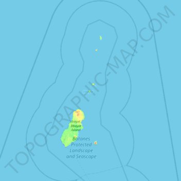
Name: Topografische Karte Itbayat, Höhe, Relief.
Ort: Itbayat, Batanes, Cagayan Valley, 3905, Philippines (20.55277 121.63856 21.25729 122.10229)
Durchschnittliche Höhe: 1 m
Minimale Höhe: 0 m
Maximale Höhe: 431 m
Andere topografische Karten
Klicken Sie auf eine Karte, um ihre Topografie, ihre Höhe und ihr Relief anzuzeigen.
Kayuganan
Philippines > Batanes > Uyugan
Kayuganan, Uyugan, Batanes, Cagayan Valley, 3903, Philippines
Durchschnittliche Höhe: 40 m
Mount Iraya
Philippines > Batanes > Basco
Mount Iraya, Basco, Batanes, Cagayan Valley, 3900, Philippines
Durchschnittliche Höhe: 493 m
Vayang Rolling Hills
Philippines > Batanes > Basco > San Antonio
Vayang Rolling Hills, National Road, San Antonio, Basco, Batanes, Cagayan Valley, 3900, Philippines
Durchschnittliche Höhe: 25 m
Itbud
Philippines > Batanes > Uyugan
Itbud, Uyugan, Batanes, Cagayan Valley, 3903, Philippines
Durchschnittliche Höhe: 70 m
Basco
Basco, Batanes, Cagayan Valley, 3900, Philippines
Durchschnittliche Höhe: 9 m
Mabudis Island
Philippines > Batanes > Itbayat
Mabudis Island, Itbayat, Batanes, Cagayan Valley, 3905, Philippines
Durchschnittliche Höhe: 7 m
Batan Islands
Philippines > Batanes > Basco
Batan Islands, Basco, Batanes, Cagayan Valley, 3900, Philippines
Durchschnittliche Höhe: 0 m