
Topografische Karte Beverly
Interaktive Karte
Klicken Sie auf die Karte, um die Höhe anzuzeigen.
Über diese Karte
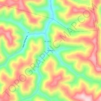
Name: Topografische Karte Beverly, Höhe, Relief.
Ort: Beverly, Bell County, Kentucky, 40913, United States (36.91037 -83.55269 36.95037 -83.51269)
Durchschnittliche Höhe: 526 m
Minimale Höhe: 368 m
Maximale Höhe: 673 m
Andere topografische Karten
Klicken Sie auf eine Karte, um ihre Topografie, ihre Höhe und ihr Relief anzuzeigen.
Fourmile
United States > Kentucky > Bell County
Fourmile, Bell County, Kentucky, 40939, United States
Durchschnittliche Höhe: 406 m
Arjay
United States > Kentucky > Bell County
Arjay, Bell County, Kentucky, 40902, United States
Durchschnittliche Höhe: 464 m
Stoney Fork
United States > Kentucky > Bell County
Stoney Fork, Bell County, Kentucky, United States
Durchschnittliche Höhe: 519 m
Calvin
United States > Kentucky > Bell County
Calvin, Bell County, Kentucky, 40813, United States
Durchschnittliche Höhe: 395 m
Kettle Island
United States > Kentucky > Bell County
Kettle Island, Bell County, Kentucky, 40988, United States
Durchschnittliche Höhe: 469 m
Miracle
United States > Kentucky > Bell County
Miracle, Bell County, Kentucky, 40988, United States
Durchschnittliche Höhe: 413 m
Middlesborough
United States > Kentucky > Bell County
Middlesborough, Bell County, Kentucky, United States
Durchschnittliche Höhe: 406 m
Pineville
United States > Kentucky > Bell County
Pineville, Bell County, Kentucky, United States
Durchschnittliche Höhe: 426 m