
Topografische Karte Floyd
Interaktive Karte
Klicken Sie auf die Karte, um die Höhe anzuzeigen.
Über diese Karte
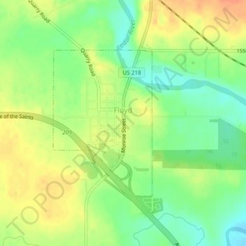
Name: Topografische Karte Floyd, Höhe, Relief.
Ort: Floyd, Floyd County, Iowa, United States (43.11843 -92.74710 43.13446 -92.73218)
Durchschnittliche Höhe: 323 m
Minimale Höhe: 301 m
Maximale Höhe: 345 m
Andere topografische Karten
Klicken Sie auf eine Karte, um ihre Topografie, ihre Höhe und ihr Relief anzuzeigen.
Charles City
United States > Iowa > Floyd County
Charles City, Floyd County, Iowa, 50616, United States
Durchschnittliche Höhe: 315 m
Marble Rock
United States > Iowa > Floyd County
Marble Rock, Floyd County, Iowa, 50653, United States
Durchschnittliche Höhe: 308 m
Rockford
United States > Iowa > Floyd County
Rockford, Floyd County, Iowa, United States
Durchschnittliche Höhe: 311 m
Colwell
United States > Iowa > Floyd County
Colwell, Floyd County, Iowa, United States
Durchschnittliche Höhe: 343 m
Nora Springs
United States > Iowa > Floyd County
Nora Springs, Floyd County, Iowa, 50458, United States
Durchschnittliche Höhe: 333 m
Rudd
United States > Iowa > Floyd County
Rudd, Floyd County, Iowa, United States
Durchschnittliche Höhe: 339 m